
(if you are reading this in the distant future some of the dashboards below may have updated to reflect new data or formatting, or they may be broken, or they may no longer make sense. To see the original images for this post please refer to this twitter thread.)
High Temperatures
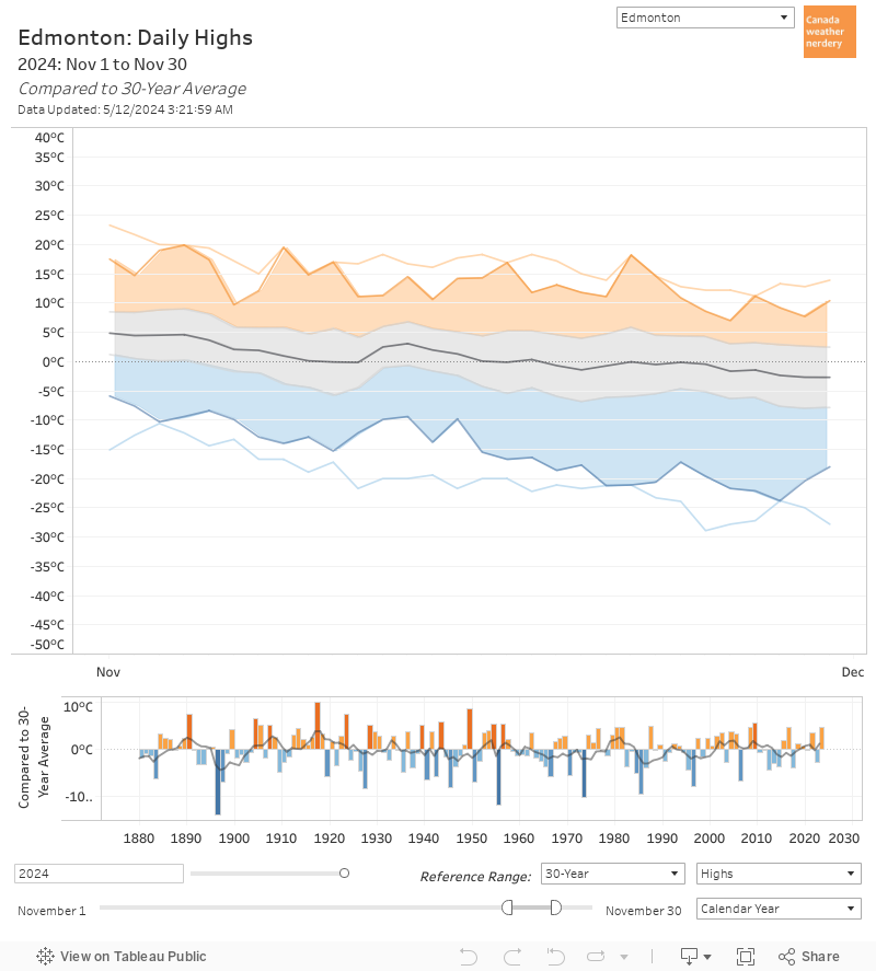 November 2021 didn't have any scorching hot days, but we were near the top of our 30-year range at the beginning of the month, and then again at the end.
Overall 25 Highs were above average, with only 5 below average.
 On average in November we have 18 Highs above freezing, and in 2021 we had 25.
That included 2 Highs above 10°C, which is average.
On average in November we have 18 Highs above freezing, and in 2021 we had 25.
That included 2 Highs above 10°C, which is average.
We didn't have any Highs below -5°C, which also happened in 2015, 2009, 2008, 2004...
Low Temperatures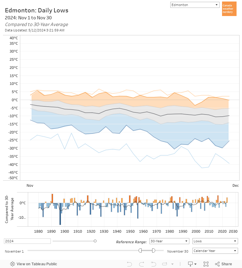 November 2021's Low temperatures were a little more average than the Highs, with 17 above average and 13 below.
The coldest Low was -16.2°C on the 24th.
November 2021's Low temperatures were a little more average than the Highs, with 17 above average and 13 below.
The coldest Low was -16.2°C on the 24th.
 November 2021 had 2 Lows below -15°C, with -15.1°C on the 23rd and -16.2°C on the 24th.
Low Temperatures
In comparison, another mild November like 2016 didn't even have a Low hit -10°C.
On the other hand, November 2010-2015 all hit -20°C, or even -25°C.
Warm & Cold Months The average High for this mild November 2021 was 4.1°C, which ranks as the 29th warmest November on record. The average Low of -6.2°C was the 47th.
Warm & Cold Months
So while we didn't have any deepfreezes, this was not an unusually warm November, and it was well below 2016, 2009, 2008...
 One thing that might feel a little strange this year is that November often throws a little coldsnap at us, to let us know that winter is here.
So far that hasn't happened.
One thing that might feel a little strange this year is that November often throws a little coldsnap at us, to let us know that winter is here.
So far that hasn't happened.
 November 2021 is our 6th above-average month in a row.
October was just a little warm, the summer months were all very warm, and May was actually a little below average.
November 2021 is our 6th above-average month in a row.
October was just a little warm, the summer months were all very warm, and May was actually a little below average.
Across Canada November was another warm month across Canada, especially in the prairies.
Across Canada
In Vancouver and central Canada the Highs were about 1°C warmer than November's 20th century average.
Meanwhile Regina, Winnipeg and Edmonton were around 3°C warmer, and Calgary was 5°C.
 Even with Calgary's warm November, 2021 didn't crack their top-10 list of warmest Novembers.
Their warmest November on record was 1917, with an average High of 13.1°C.
Even with Calgary's warm November, 2021 didn't crack their top-10 list of warmest Novembers.
Their warmest November on record was 1917, with an average High of 13.1°C.
The Horserace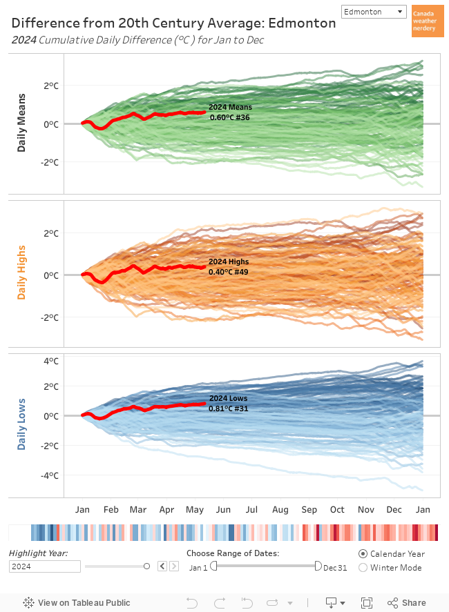 With one month left to go 2021 ranks as Edmonton's 5th warmest year on record, on pace for 2.1°C above the 20th century average.
Separately, the Highs for the year rank as 5th warmest, with the Lows as 10th warmest.
With one month left to go 2021 ranks as Edmonton's 5th warmest year on record, on pace for 2.1°C above the 20th century average.
Separately, the Highs for the year rank as 5th warmest, with the Lows as 10th warmest.
 Across Canada 2021's Highs are currently top-10 for each of these cities, except Vancouver. For Winnipeg it's currently #1.
The Horserace
The Lows are also top-10 in Edmonton, Calgary, Ottawa, Montréal, and St. John's; top-20 in Vancouver, Regina, and Winnipeg; and then #30 in Toronto.
Precipitation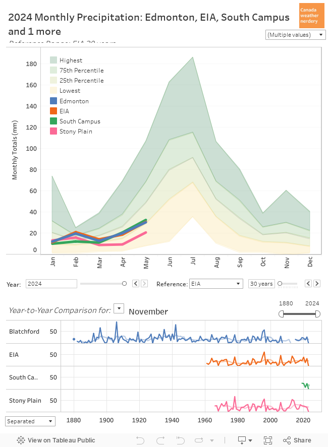 November averages 20mm or precipitation, and this year Stony Plain was just a bit above that at 23mm, while Blatchford and the airport were at 15mm. South Campus had 8mm.
Cumulative Precipitation By the end of November our total precipitation averages 422mm.
Precipitation
Cumulative Precipitation
For 2021 the airport has 325mm, Stony Plain has 299mm, and South Campus has 242mm.
Blatchford's 235mm is probably its driest year ever recorded (some years have missing data, which complicates things).
Precipitation Across Canada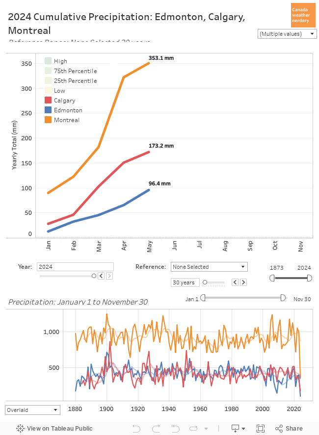 For precipitation in cities across the country:
Precipitation Across Canada
St. John's is way up near 1,300mm, with Vancouver over 1,000mm.
The central Canadian cities are around ~750mm.
Calgary, Regina and Winnipeg are around 350mm, while Edmonton is down at 235mm.
 The story of November 2021 is Vancouver though, with 312mm of precipitation.
That's more than Blatchford has recorded in all of 2021.
However it's also only Vancouver's 9th rainiest November, and well below the 398mm in November 1909.
The story of November 2021 is Vancouver though, with 312mm of precipitation.
That's more than Blatchford has recorded in all of 2021.
However it's also only Vancouver's 9th rainiest November, and well below the 398mm in November 1909.
Snow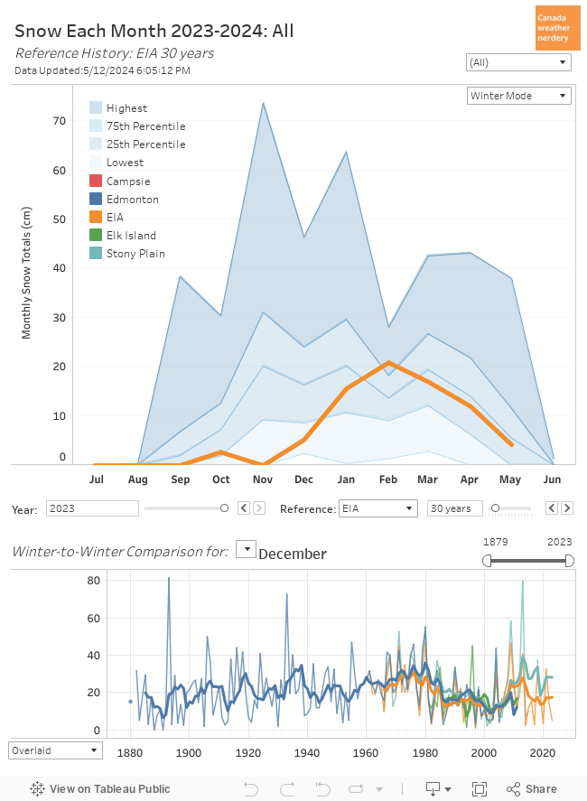 November brought our first snow of the winter of 2021-2022.
November averages 20cm of snow, and this year we got 15.4cm.
November brought our first snow of the winter of 2021-2022.
November averages 20cm of snow, and this year we got 15.4cm.
Our first snow of the winter was on November 14th.
That is one of Edmonton's latest first snows, tying 1987 and 1891.
Snow
The only later first snow on record was December 1st, 1886. Maybe that one is valid, or maybe they missed a snow measurement? There's no way to know.
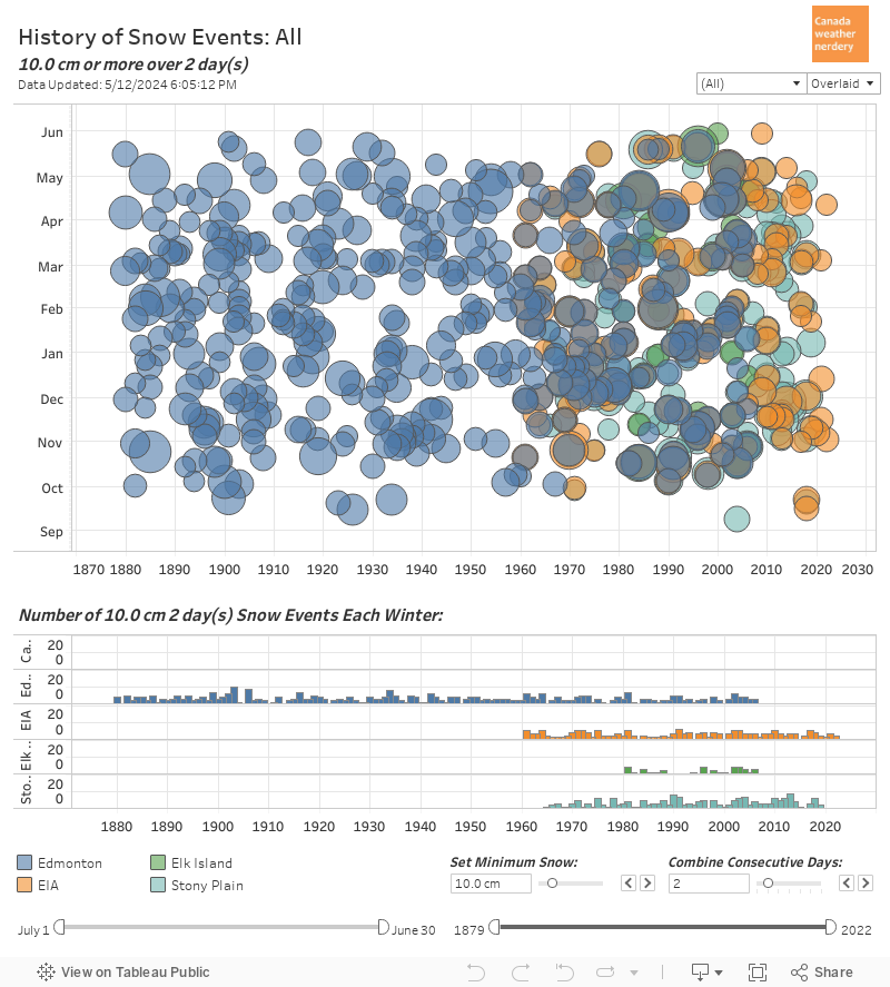 On November 15th and 16th we received a total of 12.8cm of snow, which made it our first 10cm+ storm of the winter.
In a typical winter we only get 1 or 2 of those, although 2018-2019 had 4 and 2017-2018 had 5.
On November 15th and 16th we received a total of 12.8cm of snow, which made it our first 10cm+ storm of the winter.
In a typical winter we only get 1 or 2 of those, although 2018-2019 had 4 and 2017-2018 had 5.
Snowdepth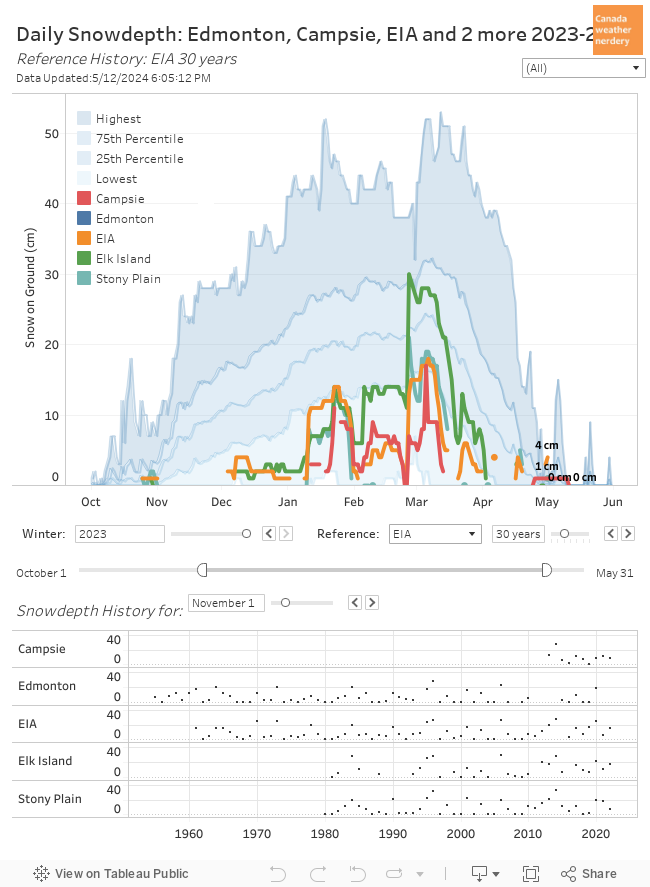 Blatchford apparently isn't recording snowdepth anymore, which is annoying.
But after the storm the airport reached 14cm, while Stony Plain hit 26cm.
With the recent warm weather those dropped to 6cm and 18cm respectively.
Blatchford apparently isn't recording snowdepth anymore, which is annoying.
But after the storm the airport reached 14cm, while Stony Plain hit 26cm.
With the recent warm weather those dropped to 6cm and 18cm respectively.
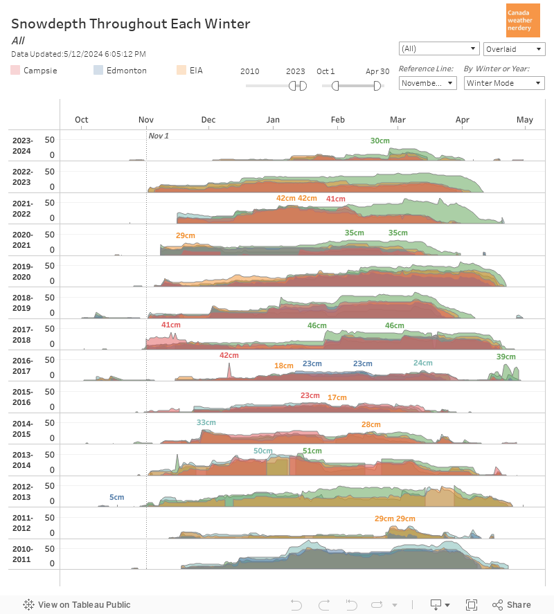 With our late first snowfall, our snow on the ground also got off to a slow start coming a week or two later than most winters.
Snow Across Canada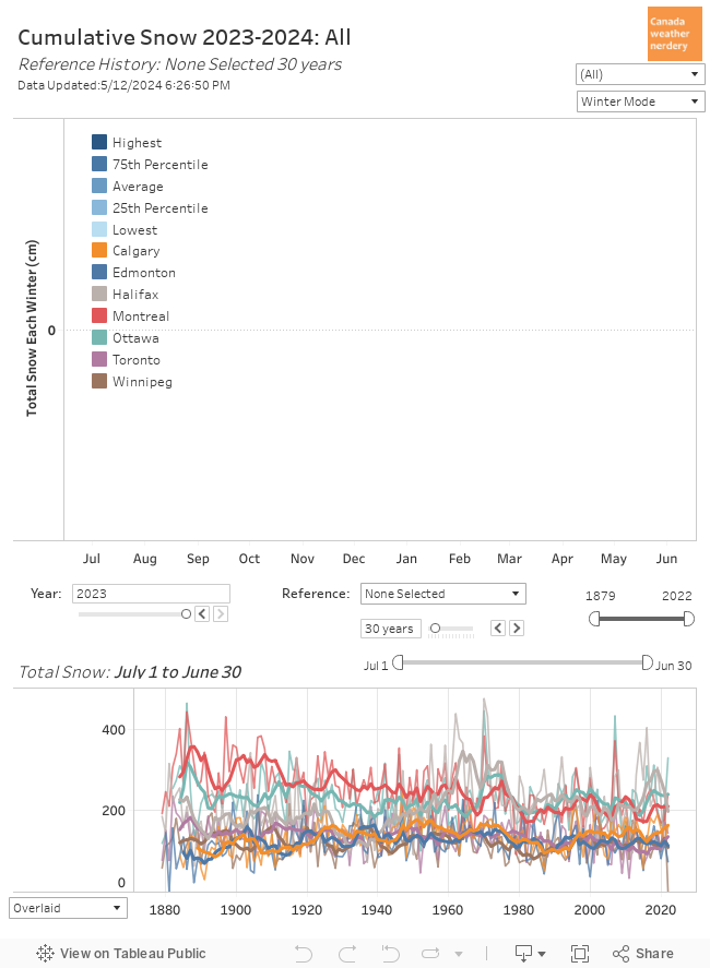 Here we have the snowfall for cities across Canada.
Winnipeg is off to an early lead with 26cm, with Edmonton and Toronto next with 15.4cm. Calgary has 9cm. And Montréal is at 4cm with Ottawa at 3cm.
Here we have the snowfall for cities across Canada.
Winnipeg is off to an early lead with 26cm, with Edmonton and Toronto next with 15.4cm. Calgary has 9cm. And Montréal is at 4cm with Ottawa at 3cm.
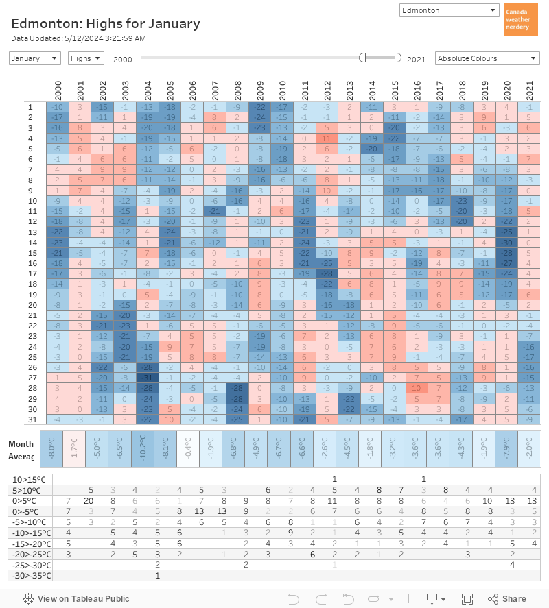
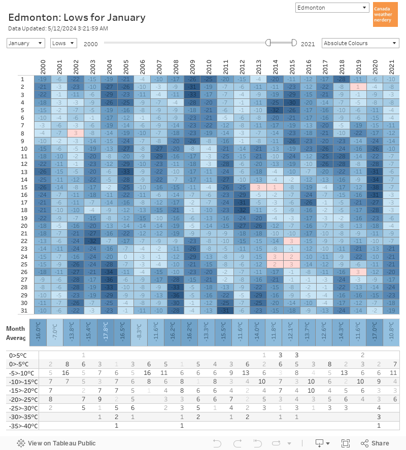
December Temperatures
In December we average about 10 days with Highs above 0°C.
For the Lows, since 1990 there have been 5 Decembers which didn't hit -20°C, and about half of the time December will hit -25°C.
December averages 16cm of snow.
Snowdepth
Snow Across Canada
December Temperatures
No comments:
Post a Comment