Today we are going to take a look back at the weather for March 2021.
We will talk a bit about the winter in general too, but if you are interested in how the winter of 2020-2021 compared overall we had a detailed look at it a few weeks ago in 2020-2021 Winter In Review: Temperatures.
March 2021 High Temperatures
Here we have the High temperatures for March 2021. We ended up with 5 Highs which were colder than the 30-year average, compared to 26 which warmer. And that included 2 warmest-in-30-year Highs on March 17th at 12.6°C and March 18th at 15.8°C.
One of the cruel tricks of Alberta weather is that the start of March was warmer than the end. We jumped from "winter" to "spring," and it felt let we were on the way to "summer," but unsurprisingly the real summer is still many months away. The end of the month certainly felt a lot colder than the start did, but it was all pretty typical for March.
Looking at the numbers we only had 2 Highs below freezing, compared to an average of about 11 for March. On the other end we had 10 Highs above 10°C, when March averages about 4. And that included 1 High above 15°C, which in recent years had only happened in 2019, 2015, 2010 and 2004.
March 2021 Low Temperatures
For the Low temperatures we had 8 below average, compared to 23 above. And that included 3 warmest-in-30-year Lows, including a new record-warmest Low of 3.9°C on March 14th.
Our coldest Low this month was -14.1°C on March 14. In total we had 3 Lows below -10°C, while March averages 10. The only recent Marches which didn't hit -15°C were 2010, 2016 and now 2021. March 2017-2020 all hit -20°C at least once, with 2019 having 3 Lows which dropped below -25°C.
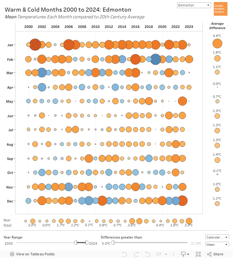
Warm and Cold Months
So overall March 2021 was a pretty warm month.
Its average High ranked as 5th Highest, and 5.8°C warmer than March's average. It was the warmest March Highs since 4th place 1988, which was just tiny bit warmer. Before that we need to go back to 1910, which is in 1st place with an average High of 10.7°C.
The Lows weren't quite as unusual, ending up in 14th spot at about 3.5°C warmer than average. Recently March 2016, 2015 and 2010 all had warmer average Lows.
In this chart orange bubbles represent months where the Mean temperature (the average of the Highs and the Lows) was warmer than the 20th century average, while blue bubbles were colder.
March 2021 is a fairly large orange bubble at 5.8°C warmer than the 20th century average. That is about the same size as March 2016 and a little bit bigger than March 2015. It follows a cool February and a warm January this year.
Across Canada
Looking across Canada it was a warm March in all of these cities, but especially on the prairies. Winnipeg was at the top at 6.8°C warmer than its 20th century average temperature for March.
2021 So Far
In this chart the red line shows how the temperatures each day compared to the average temperature for the 20th century. When days were above-average days the line goes up, and for below-average days it drops.
After 3 month of 2021 we have had Edmonton's 25th warmest start to a year. Things got off to a really warm start in January, but the red lines all take a significant dip for the coldsnap in late-January and early-February. But after that things start climbing again through March.
In this chart each of the bars represents the average temperature for January-March compared to the 20th century average for each of these cities.
Looking across the country again, most of the cities here have had a top-25 warmest January-March, with Toronto, Calgary and Vancouver as the exceptions at around the 40th spot.
Snowfall
The International Airport recorded 5.5cm of snow in March, which is below the average of 19cm. This winter February's snow was right on the average, November's was above, and all of the other months have been low.
For the winter so far we have had 68.3cm of snow, which is well below the average of 100cm for this point in the winter. But, in April and May we do average another 20cm of snow, so the snow season probably isn't over.
This chart has the snowfall totals for cities across Canada. It is a little tough to read, but out 68.3cm of snow just pushes us above Winnipeg's 66.2cm. Next is Toronto at 100cm. Calgary, Ottawa and Montréal are all from 138-164cm, and St. John's is up at 282cm.
Most of these numbers are within the typical ranges for these cities. The biggest outliers are Edmonton and Winnipeg which are quite low, while Calgary's 138cm is above its average of 112cm.
Snowdepth
In terms of snowdepth, the warm temperatures at the start of March gave us an early melt. Blatchford's last recorded snow was on March 9th, and the International's was on March 20th. But then the International did pop up to 4cm with some fresh snow on March 29th.
And across Canada the warm March meant that all of these stations were snow-free by the end of March.
April Temperatures
For April temperatures on-average it only has 3 Highs below 0°C, and about three-quarters of the time April will have a day hit 20°C. 2001, 2015, 2016, and 2018 all had days hit 25°C.
In recent years April 2020 and April 2018 both started quite cold though. We hadn't had a -20°C Low in April since 1982, but April 2nd 2020 broke that streak hitting -20.8°C. More typically though, only about one-third of recent Aprils had any Lows which hit -10°C.
We almost certainly haven't seen the end of the snow though, because in April and May we average another 15cm and 6cm of snow respectively.


 If this April 10th storm really is our final snow for the year it would be the earliest final snowfall at the International since 1998.
 Our April 10th storm was 4.2cm, and so for comparison this chart shows every 4cm+ storm for April and May. This year's storm is the small~ish bubble furthest to the right.