2019/03/31

March 2019 Review / April 2019 Preview

March 2019 in three words: cold, warm, average.

...and for a few more words, it was also a bit less snowy than usual.

Let's take a look.


Aujourd'hui je vais essayer quelque chose de nouveau. J'ai besoin de pratiquer mon français, et donc: Edmonton Weather Nerdery est maintenant disponible en français. Je m'excuse pour toutes les erreurs que je vais faire. Et les graphiques doivent rester en anglais, malheureusement.

En discutant de mars 2019 il y a trois mots importants: froid, chaud, moyen (et de plus, il y avait moins de neige que d'habitude). On commence:

High Temperatures

Last month we talked about the generationally cold February of 2019, and those cold temperatures carried into the first week-and-a-half of March. But then things flipped fairly quickly, and the week of the 18th-24th had a mini-heatwave, with 6 days in a row hitting warmest-since-1996 Highs. We were still a few degrees below the warmest-since-1880 records though. Then for the final week of March things cooled off a bit to around the average.

Février 2019 était le cinquième plus froid février depuis 1880, et ça a continué en mars. Mais ça a changé au milieu du mois lorsque la température a augmenté beaucoup. Nous avons eu six jours avec des temperatures le plus chaud depuis 1996, tout en restant en dessous des records de 1880.


With an average High of 3°C March 2019 was on the warmer side of recent years. March 2018 & 2017 were at 0.3°C & 0.4°C respectively, and a truly cold March like 2002 was way down at -6.4°C. But recent warm Marches like 2017 & 2016 were up at 7.0°C and 6.4°C respectively.

We had 2 Highs of -15°C or colder, and two-thirds of the time March doesn't have any Highs that cold. But we also had 2 Highs of 15°C or warmer, and only 20% of recent Marches have had any days that warm. We had 22 days which hit 0°C or warmer, and that's just a bit above the average of 20 days.

La température maximale moyenne pour mars était 3°C, qui était un peu chaud par rapport aux autres mars récents. Mars 2018 & 2017 étaient tous les deux froids, mais récemment mars 2002 était le plus froid avec un la température maximale moyenne de seulement -6.4°C. Et le mars récent le plus chaud était 2017 avec une température maximale moyenne de 7.0°C.

Nous avons eu deux températures maximales de -15°C, alors que la plupart des mars n'en ont aucune. Par contre, nous avons eu également deux jours presque chauds, avec des températures maximales dessus de 15°C, qui est aussi rare. 22 jours étaient au-dessus de la point de congélation, en comparaison à une moyenne de 20.


Low Temperatures

For Low temperatures the cold start to the month had one coldest-since-1996 Low, but that was still almost 10°C warmer than the coldest-since-1880 record. The end of the month was consistently above average by a few degrees.

We're getting to the point in the year where the range of likely Low temperatures really starts to shrink. March starts with a recent history of Lows ranging from -30°C to 0°C, and by the end of April that shrinks to from -5°C to 5°C.

Au debut du mois de mars les températures minimales étaient froid, mais encore presque 10°C plus chaud que les records de 1880. A la fin du mois les températures minimales étaient un peu plus chaud que la moyenne.

Nous approchons de la partie de l'année où les températures minimales deviennent moins aléatoires. Au debut de mars les températures minimales peuvent être entre -30°C à 0°C, mais par la fin d'avril cette gamme diminuera à -5°C à 5°C.


March's average Low of -8.4°C was right around the 20-year average of 8°C. A warm March like 2016 had an average Low of -2.4°C, while 2002 was way down at -16.2°C.

This March we had 3 Lows of -25°C or colder, and only 6 of the past 20 Marches had any days that cold. We also had 4 -20°C Lows, and those only happen about half of the time.

It's also worth remembering that last year March 2018 ended with a Low of -20°C on the 30th, which just wasn't fair.

La température minimale moyenne pour mars était -8.4°C, qui était presque la même que la moyenne sur 20 ans de 8°C. Un mars tres chaud comme 2016 avais une température minimale moyenne de -2.4°C, alors qu'un mars froid comme 2002 avais seulement -16.2°C. 

Ce mars nous avons eu trois températures minimales de -25°C. La dernière fois que nous sommes tombés à -25°C en mars était en 2014, et ça n'arrive que le quart du temps. Les températures de -20°C en mars sont presentes la moitié du temps. Rappelons également qu'en 2018 nous avons eu un -20°C à la fin du mois le 31 mars.


Warm & Cold Months

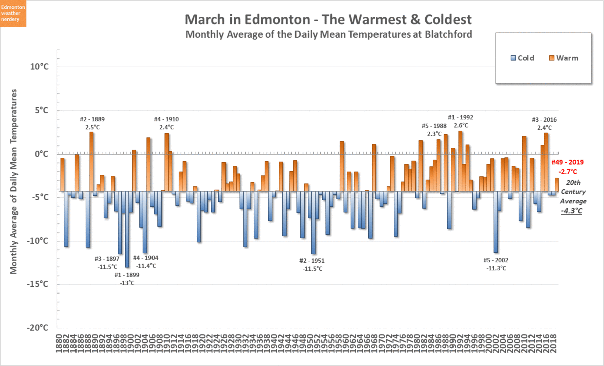
When we add up all of the Highs and the Lows the average temperature for March 2019 was -2.7°C, which made it the 49th warmest March since 1880. That's well above 2018 & 2017, but below 2016 & 2015.

The average High of 3°C ranks as the 44th warmest High, and the Low of -8.4°C is 52nd warmest.

Looking at the 10-year average (dotted red lines) we can see that March's average High hasn't changed too much over that past century. Right now the average is around 2°C, and in the 1950s it was down around -2°C, but around 1900 it was around 1°C. So the Highs have flopped around a bit. The Lows have fairly steadily increased though, from -12°C a century ago to -8°C today.

En tenant compte de toutes les temperatures maximales et minimales la temperature moyenne de mars 2019 était -2.7°C. Ça l'en fait le 49ème plus chaud mars depuis 1880. 2018 & 2017 étaient plus froids, mais 2016 & 2015 étaient plus chauds.

Pour les températures maximales, elles n'ont pas changé beaucoup pendant du siècle dernier. Mais les températures minimales ont augmentées d'environ -12°C il y a un siècle à -8°C aujourd'hui.


March's ranking as 49th warmest is a little boring after our very cold February (5th coldest) and pretty warm January (16th warmest), but is in the same range that November and December were.

Mars étant le 49ème le plus chaud n'est pas aussi intéressant que février qui était le 5ème plus froid ou janvier le 16ème le plus chaud. Mais mars était pareil à Novembre et Décembre.


Snow

March 2019 only recorded 1 day (or 1 "days", as the chart says) with snow at the International. The average for March is 9 days, March 2018 had 11 days, and in recent years March 2010 had been the lowest with 4 days. So this was a very unsnowy March.

Mars n'avait qu'un jour avec de neige à l'aéroport, ce qui est beaucoup moins que habitude. La moyenne pour mars est 9 jours, et récemment l'année la plus basse était 2010 avec 4 jours.


Even though March 2019 only recorded a single day with snow, that one day produced an impressive 12.8cm. March's average snowfall is around 20cm, and last year in 2018 we had 28.2cm.

Bien que mars avait seulement un jour de neige, ce jour-là a atteint 12.8cm, qui est impressionnant. La neige moyenne en mars est de 20cm, et l'année dernière nous en avons reçu 28.2cm.


Snowdepth

In early March the snowdepth at the International and Blatchford were both way up near the top of the recent range, peaking at 45cm and 37cm respectively. But that started to drop rapidly around the middle of the month. Blatchford first hit 0cm on the 23rd, although it bounced back up to 1cm for a few days before settling at 0cm on the 30th. And on March 31st the International dropped to "trace" amounts for the first time, which isn't quite 0cm, but it's close.

The snowdepth from last winter is shown as the dotted red line, and the cold April 2018 delayed the start of the melt by almost a month.

Au debut de mars la profondeur de neige à l'aéroport et à Blatchford était tres élevée, culminant à 45cm and 37cm respectivement. Puis au milieu du mois il a commencé à baisser rapidement. Blatchford a atteint 0cm le 23, bien que il a regagné un peu plus après. L'aéroport est pres de zero, mais n'y est pas encore arrivé. La profondeur de neige pour l'année dernière est montré également par la ligne rouge, et avril 2018 était tres froid qui a retardé la fonte de près d'un mois. 

Lets take a look at a few more charts of the melt:

Voici plus de graphiques au sujet de la grande fonte printanière:


Blatchford is missing a few years of snowdepth data, so here we have the snowdepth each year at the International airport.

At the start of March the average snowdepth is about 20cm, and by the beginning of April that falls to around 7cm. In recent years 2010, 2012, 2015, 2016 & 2017 were all at around 0cm by the start of April, while 2009, 2011, 2013 & 2018 were all still up above 20cm.

Blatchford manque plusieurs années de données, et à cause de ça nous utilisons typiquement les données de l'aéroport pour la profondeur de neige.

Au debut de mars la profondeur de neige moyenne à l'aéroport est d'environ 20cm, mais ça tombe a 7cm au debut d'avril. Récemment 2010, 2012, 2015, 2016 & 2017 étaient toutes pres de 0cm au debut d'avril, alors que 2009, 2011, 2013 & 2018 avaient plus de 20cm.

And let's do one more:

Et un autre:


This chart shows how long the melt takes...and that even once we've hit 0cm for the first time that doesn't necessarily mean that we've seen the last of the snow. For example 2017 hit 0cm in late-March, but then still spent a few weeks in April with late snow. So we'll have to see what 2019 has in store for us.

Nous voyons ici comment la neige fond au printemps. Même lorsque la profondeur tombe à 0cm ça ne signifie pas nécessairement que l'hiver est terminé. Par example, en 2017 la profondeur a atteint 0cm tres tôt en mars, mais il restait encore deux semaines de neige plus tard en avril. On vera ce qui arrivera en 2019.


Precipitation

It's the time of the year where we switch from talking about snow to talking about precipitation in general. And March 2019 was below the average of 19mm, with the International at 10mm and Blatchford at 5mm.

Nous entrons dans la partie de l'année où nous parlons plus de précipitations que de neige. Et mars 2019 était en dessous de la moyenne de 19mm, avec 10mm à l'aéroport et 5mm à Blatchford.


April Temperatures
 

Last year April 2018 started with a deepfreeze, but only about one-third of recent Aprils had any Lows hit -10°C. And we haven't had a -20°C in April since 1982, and before that it was 1975, and then 1954.

In terms of High temperatures last April had 9 Highs below freezing, which was a lot more than the average 2. But last April we also hit 28°C on April 28, and 15 of the past 20 April have had at least one day hit 20°C.

En 2018 le debut d'avril était tres froid, mais c'est plutôt rare. Nous n'avons pas eu une temperature de -20°C en avril depuis 1982. Et en avril nous aurons généralement au moins une journée avec une temperature maximale de 20°C. L'avril dernier nous avons même atteint 28°C le 28 April.

As much as it might feel like winter is over, in April and May we average another 15cm and 6cm of snow respectively. Or, in recent years we've had snow in April 96% of the time, and in May 54% of the time:

Même si tout le monde espere que l'hiver est fini, nous aurons encore plus de neige. En avril nous avons de la neige 96% du temps, et la moyenne des chutes de neige est 15cm. Et en mai nous avons de la neige la moitié du temps, avec une moyenne de 6cm:

2019/03/22

Freeze/Thaw Cycles: Part 2 - Versus Round

Last week in Free/Thaw Cycles: Part 1 we looked at how the number of freeze/thaw cycles in Edmonton each year has changed over time. Today we are going to expand that to look at a few of Canada's other winter cities.

The weather stations which we will be comparing today are:
    • Edmonton Blatchford (2km from downtown)
    • Edmonton International Airport (25km from downtown)
    • Calgary International Airport (9km from downtown)
    • Winnipeg International Airport (6km from downtown)
    • Montreal Airport (13km from downtown)

Each time that we look at the data from these other cities it is with the caveat that the data is not necessarily 100% equivalent because of where the stations are located. But these stations are the ones with a long history of data, and so they might not be perfect but they are what we have available.

Also, counting freeze/thaw cycles is a little bit complicated, and the methodology which we used was explained in Freeze/Thaw Cycles: Appendix.


And now, let's go:

Freeze/Thaw Cycles Each Year

Here we have the freeze/thaw cycles each year for each of the stations. The 5-year averages are included as dotted lines to get rid of some of the noise from the yearly numbers.
  • Blatchford averages about 90 freeze/thaw cycles, which has been consistent since about the 1930s. Before that it was up around 110.
  • The Edmonton International in recent years has had around 120~125 freeze/thaw cycles each year, which is up from the 110 which it used to get in the 1960s.
  • Calgary has averaged about 125 freeze/thaw cycles going back to around the 1940s. Before that it was up at around 140.
  • Winnipeg has hovered around 75 freeze/thaw cycles for the last century. Sometimes it is a bit below, and right now it is a bit above.
  • Montreal used to be at around 60 freeze/thaw cycles but right now is at around 70.

It is not surprising to see that Calgary has more freeze/thaw cycles than Edmonton, but so does the Edmonton International? And for the last 10 years the Edmonton International has almost been tied with Calgary? And obviously Winnipeg has fewer freeze/thaw cycles than Calgary or Edmonton, but Montreal is down there too for some reason? What's going on?


Freeze/Thaw Cycles Each Month

Here we have the average number of freeze/thaw cycles each month for these stations, for 2000-2018.
  • Blatchford is middle-of-the-pack for most of the year. But in the shoulder-season months - April, May, October - it's the 2nd lowest, above only Montreal. 
  • The Edmonton International is middle-of-the-pack during the winter - December, January & February. But for the rest of the year it's very high, especially in April, September & October.
  • Calgary is highest in the deep-winter months of November through March. It is middle-of-the-pack during the shoulder-season months.
  • Winnipeg is the lowest by far during December-March. It's fairly high for April-June.
  • Montreal is the lowest by far during the shoulder-season months of April, May, September & October. For December it is a little above Edmonton, and for January & February it is below.
For the yearly counts of freeze/thaw cycles we saw that Calgary and the Edmonton International had similar totals. Here can see that even though the yearly numbers are similar, they are coming from very different places. Calgary's "extra" freeze/thaw cycles are in the deep-winter, while the Edmonton International's are in the late-spring and early-autumn.

We also saw that the yearly totals for Winnipeg and Montreal were both quite low. Compared to the other cities Winnipeg is "missing" freeze/thaw cycles during the deep-winter, while for Montreal it is the spring & autumn which are very low.


Thawing Days & Freezing Nights Each Month

Here were are comparing the freeze/thaw cycles for the stations again, but this time we have added the number of Highs Above Freezing in red, and the Lows Below Freezing in blue.

In Part 1 we saw that there are different drivers for freeze/thaw cycles depending on where we are in the year. In the winter warm days are relatively rare, and so a freeze/thaw doesn't happen unless there is a warm day. On the other hand, in the spring & autumn most days are above freezing, and so a freeze/thaw doesn't happen without a cold night.

In the animated version of this chart there is a lot of stuff going on, so let's take a look at each station individually.

Blatchford

Blatchford is pretty middle-of-the-pack across the board. Its Highs Above Freezing are pretty high in January & February, but they are still below Calgary. And its Lows Below Freezing are pretty low in April, May & October, but they are still above Montreal.


Edmonton International Airport

For the Edmonton International the story is that it gets a lot of Lows Below Freezing in April, May, September & October. Its Highs Above Freezing are middle-of-the pack and a close match to Blatchford, but all of the freezing nights during the shoulder-season months are what sets it apart.


Calgary International


For Calgary it is not a surprise that there are a lot of mid-winter Highs Above Freezing. For December-February it averages about 5-7 per month more than Edmonton, 7-10 more than Montreal, and 12-15 more than Winnipeg. It's Lows Below Freezing are in the middle-of-the-pack for most of the year.


Winnipeg International

For Winnipeg the story is the lack of Highs Above Freezing during the winter, with 5~10 fewer each month for December-March than the other cities. Its Lows Below Freezing are also high from January-May, but are middle-of-the-pack for September-December.


Montreal

For Montreal the number of Lows Below Freezing is the lowest of all of the stations for almost the entire year. And its Highs above Freezing are the highest for March-November, while being a little low for December-February.


Freeze/Thaw Cycles Each Year, Again

And so here we are back where we started, with the number of freeze/thaw cycles each year for each of the stations. But this time we have also added the number of Highs above freezing in red, and the Lows below freezing in blue.

The animated version of this chart is also pretty busy, so we will break the stations out separately again.


Blatchford

For Blatchford:

  • the yearly Highs above Freezing are in the middle of the pack
  • the Lows below Freezing have fallen to the bottom of the prairie stations, but with about 175 per year they are still well above Montreal's 145ish.
  • as we saw at the start today, the freeze/thaw cycles are in the middle.


 Edmonton International Airport

For the Edmonton International:
  • the Highs above Freezing are in the middle of the pack
  • the Lows below Freezing are the highest for all of these stations.

 Calgary International

For Calgary:
  • the Highs above Freezing are the highest for all of the stations, and have stayed fairly constant at around 300 over the past century.
  • the Lows below Freezing are in the middle of the pack, and have fallen from an average of about 200 a century ago to around 175 today.
  • as we saw at the start today, the freeze/thaw cycles have decreased from about 140 to around 125 today.

Winnipeg International

For Winnipeg:
  • the Highs above Freezing are the the lowest for all of the stations, and have stayed fairly constant at around 250 over the past century.
  • the Lows below Freezing are in the middle of the pack, and have stayed at around 185 for the past century.
  • the freeze/thaw cycles have stayed constant at around 75.

Montreal

For finally, for Montreal:
  • the Highs above Freezing are above Edmonton but below Calgary, and have increased from about 275 a century ago to just under 300 today.
  • the Lows below Freezing are the very bottom, and well below these other stations. Montreal has about 150, compared to 175-200 for the others.
  • and with that the freeze/thaw cycles have increased from an average of about 60 a century ago to about 70 today.

Summary

As we saw last week in Part 1, freeze/thaw cycles have always been a part of Canadian winters. And to have a freeze/thaw cycle you need both a freeze and a thaw.

  • Calgary gets a lot of freeze/thaw cycles because it has a lot of mid-winter thaws.
  • The Edmonton International also has a lot of freeze/thaw cycles, but that's because of its many shoulder-season freezes (and it also has a reasonably high number of mid-winter melts).
  • Winnipeg's freeze/thaw cycles are low because it has very few mid-winter melts - 1/4 as many as Calgary, or 1/3 as many as Edmonton.
  • Montreal's freeze/thaw cycles are low because it doesn't have many shoulder-season freezes.

2019/03/17

Late-March Heatwaves

The forecasts for this week are looking pretty warm, so today we are looking back at some historically warm March days.


50 Warmest Days: March 18-24

This chart has the 50 warmest temperatures for the 2nd last week of March - the 18th through 24th.

The warmest records for this week are March 22nd and 23rd at 21.1°C and 22.2°C respectively, both set way back in 1889. The coldest record is almost 10°C lower, with the 24th way down at 13.6°C set in 2004. The records for the rest of the week are all between 17.2°C and 19.4°C.

In terms of decades the 1910s have 13 entries in this Top-50, across 4 years: 1910, 1911, 1912 & 1915. And the 1880s have 9, across 1884, 1885 & 1889. In comparison the 2000s only have 1 entry, with March 24th's 13.6°C record.

The cutoff to get into this Top-50 is 12.2°C, and so at the end of the week we will need to see if 2019 has added any entries.


50 Warmest Days: March 25-31

Moving on to the last week of March - the 25th through 31st - things change a little bit.

For this week the records range from 15.1°C for the 27th and 15.6°C for the 25th up to 21.1°C for the 31st and 23.5°C for the 30th. And here the cutoff for the Top-50 is 13.9°C, compared to 12.2°C for the week before.

The 2010s are much better represented here, with 7 entries across 2010, 2015 & 2016. And the 1990s have the most entries with 8, across 1990, 1991, 1992, 1994, 1995 & 1998.


Records

This upper line on this chart shows how much the records for the back-half of March vary. Most of them fall between 15°C-20°C, but there are a few outliers up above 20°C and below 15°C.


Recent Marches

In recent years 2004 was the only March with a day which hit 20°C, and 2004 & 2015 both had days hit 15°C. So those were the only particularly "hot" recent Marches.

Below that most Marches have had at least one day which hits 10°C. The recent exceptions being 2018, 2011, 2006 & 2002. And we've already had one of those in 2019.


The Big Melt

Last week was fairly warm, and here we see the effect it has already had at the snowdepth at the International Airport. The airport peaked this winter at 45cm on March 10, but dropped to 35cm by the 16th. Last winter late-March and early-April were both very cold, so the big melt in 2017-2018 didn't start until mid-April.


Here's one more look at how snowdepth changes over the course of March & April.

This year we started March well above average at 37cm, and in Mid-March we're still well above average. But by April 1st many previous years have melted down to 0cm or near 0cm. The forecast for the rest of March is looking fairly warm, so we will have to see where we end up in a few weeks.


Updated for 2019:

So in the end, the week of March 18-24 ended up with 5 Highs in the Top-50. And those are the only entries in the Top-50 for the 2010s.


Those 5 days all set warmest-since-1996 temperatures, but they were still a few degrees below the warmest-since-1880 records.


And the warm week made a dent in our snowdepth, with Blatchford dropping down to 1cm, and the International falling to around 20cm.

2019/03/12

Freeze/Thaw Cycles: Part 1

Today we are going to take a look at the history of Edmonton's freeze/thaw cycles.

This post was written way back in mid-January under the assumption that we would have a typically melty February. As we will see today, during February we on-average get about 10 days above freezing.  Instead though, February 2019 was meltless and was the coldest February in generations. But now it seems that our long, long coldsnap is finally over, so let's talk about melting.

The question of how exactly to count freeze/thaw cycles is actually a little bit complicated. If you are interested in the specifics and assumptions behind the numbers today those are outlined in a separate post Freeze/Thaw Cycles: Appendix. The short version is:
  • we will be using Daily High & Low temperatures to count freeze/thaws.
  • the numbers today won't necessarily be 100% accurate, but for year-to-year comparisons they should at least be consistent.

With that house-keeping out of the way...

Freeze/Thaw Cycles Each Year


Here we have the number of freeze/thaw cycles each year going back to 1880. The 5-Year average appears as a dotted red line to show how things have changed over time.

Right now we average about 91 freeze/thaw cycles per year. In recent years that has ranged from around 120 for a year like 2004 down to around 70 for 20014, but most years are in the range of 80-100.

That average of about 90 freeze/thaw cycles per year has been relatively consistent for the last 90 years, going back to 1930. And before that the average was quite a bit higher, with around 110~115 freeze/thaw cycles per year.

So for the last 90 years the number of freeze/thaw cycles has not changed much, and before that we used to get more? That can't be right, can it? These numbers might seem counter-intuitive, but we will want to keep this in mind today: a freeze/thaw cycle needs a thaw and a freeze.

Hopefully by the end of today we will have a better idea of what is going on here.


Freeze/Thaw Cycles Each Month


Here the freeze/thaw cycles have been broken out by month, and the chart cycles through the average for each decade going back to the 1880s. The faint grey lines in the background show the ranges of all of the decades, and the 2010s are dotted-in in red for an easy comparison. Both the 1880s and 2010s only include 9 years (1881-1889 and 2010-2018), so they aren't quite full decades.

The months which have the most freeze/thaw cycles are March, April, October & November. That is probably not surprising, because those are the main spring/autumn months. And over the decades those months have all averaged from 12-18 cycles each month.

What might be a bit surprising is that we also have quite a few freezes/thaws in the middle of winter, with December, January & February all averaging 6-11 cycles each month. That is about half the number of cycles that the big months get, and it is not a new thing. In the 1880s January averaged 6 freeze/thaws, but in the 1890s it was 9. In more recent history the 1980s were at 10, the 1990s were down at 7, and the 2000s and 2010s were both up at 11. Right now we have been up at the top of the historic range for January, but that still only works out to a few extra freeze/thaw cycles per month.

Focusing on the red line for the 2010s:
  • January & February are near the top of the historic range.
  • March & December are in the middle of the range.
  • April, May, September, October & November are all at or near the bottom of the range.

In the first chart today we saw that our freeze/thaw cycles have actually decreased over time. Here we can see that in January & February the numbers have gone up a bit, but for the rest of the months they have dropped.


Freeze/Thaw Cycles Each Week


In this chart we have broken things down even further to the number of freeze/thaw cycles for each week of the year. (the numbers for week 4 of each month have been been adjusted so that they are comparable to all of the other 7-day weeks)

Looking at the historic range (the grey cloud in the background) the number of freeze/thaw cycles trends upwards each week from January through the end of March, and then with the beginning of April it starts to drop off rapidly to the end of May. In the autumn things are reversed, with a fairly quick increase starting in September and peaking at Halloween, and then a slightly slower dropoff towards New Year's.

When we look at the line for the 2010s we again see:
  • January & February weeks are near the top of the range, which means maybe 1 extra freeze/thaw cycle per week on average. 
  • Early-spring (March & early-April) are middle of the pack.
  • Late-spring (Late-April & May) are near the very bottom.
  • Autumn & early-winter (September, October & November) are near the very bottom.
  • December is middle of the pack.

So why are our recent numbers so low in late-spring, autumn, and early-winter? Earlier we had said that a freeze/thaw cycle needs a thaw and a freeze, and now we are going to look at why that is important.


Here we have the same data which we were just looking at - the average number of freeze/thaw cycles per decade - but we have also added the number of Highs Above Freezing in red, and the Lows Below Freezing in blue.

As this chart cycles through the decades we see that:
  • During the winter from November-March the number of freeze/thaw cycles follows the red line for Highs Above Freezing very closely. In the winter most nights are going to be cold, and so the only way to have a freeze/thaw cycle is to have a warm day.
  • For April-October the freeze/thaw cycles follow the blue line for Lows Below Freezing. In the spring/summer/autumn most of the days are warm, and so cold nights are the trigger for a freeze/thaw.

Depending where we are during the year the freeze/thaw cycles have different drivers. In the winter they are driven by warm days, and in the spring & autumn the cold nights are important.


Here we are just focusing on the 2010s:
  • We have gained freeze/thaw cycles in January-March because of more warm days.
  • We have lost freeze/thaw cycles in April-May and September-November because of fewer cold nights.
  • We have also lost freeze/thaw cycles in late-November and December because of fewer warm days.
Why have January & February warmed up while November & December haven't? Who knows. But it was something which we also saw in more detail in The Months through the Years.


Freeze/Thaw Cycles Each Year, Again


And so here we are back where we started, with the number of freeze/thaw cycles each year. But this time we have also added the number of Highs above freezing in red, and the Lows below freezing in blue.
  • The number of Highs above freezing has stayed very consistent, with an average of about 281 per year since the 1890s.
  • The number of Lows below freezing has dropped a bit, from 192 a century ago to 174 today.
  • We saw earlier that for the past 90 years our average number of freeze/thaw cycles each year has stayed fairly constant at around 90. Before that it was about 20 higher at 112.

When we think of freeze/thaw cycles we probably focus on the thawing part of it, but that has stayed about the same over the years. What has changed is that we have lost some freezing nights, and with that we have also lost some freeze/thaw cycles.

It might seem strange that our number of Highs above Freezing has not changed much over the last century, but it is something that we have seen before, most recently in The Months Through the Years:


The background of this chart is the distribution of our High temperatures since 1996. 

The 1996-2018 average High for each day is the white line which runs through the middle of the chart. The red line which appears shows the average Highs from 1880-1889. Our modern Highs are warmer in January, February, and late November, but for most of the year things have not changed very much. 

In comparison here are the 1880-1889 Lows:


For the Lows temperatures our modern averages are shifted up 3-5°C compared to where they were a century ago.

With that temperature shift our "season" of Lows-below-freezing has gotten shorter by about 2 weeks in April and October, which is why we have lost on-average about 20 Lows below freezing. But for the Highs-above-freezing the season has stayed consistent as mid-March to early-November.


1920s & 1930s

One final question from our yearly chart is why the number of freeze/thaw cycles took a sharp step down around 1930. This chart shows the 1910s through 1940s so that we can take a closer look at what was going on there.

There is a lot going on in this chart, but here are some things to watch for:
  • The 1910s & 1920s both had a lot of Lows Below Freezing (blue line) in April and May, and a lot of Highs Above Freezing (red line) in October. So cool spring nights and warm autumn days meant a lot of freeze/thaw cycles.
  • In the 1930s the number of cool spring nights and warm autumn days both fell. Those might seem like they are opposites, but they both cause the number of freeze/thaw cycles to drop.
  • Then in the 1940s the number of cool spring nights stayed fairly low. It did have more warm autumn days than the 1930s, but also less warm days in November & December.
We don't know why these changes happened from decade-to-decade, but this explains why the chart shows such a noticeable change.


The 2010's


Today we have mostly focused on how things have changed over the different decades, but in this final chart we are comparing the individual years from 2010-2018 (and Jan-Feb 2019).

For 2018 the notable months were May which had very few freeze/thaw cycles, and then SeptemberOctober & November had lots. And for 2019 so far January was average, while February was one of only 15 months since 1880 with no days above freezing.

And here are some of the extremes:
  • January 2010 had 7 freeze/thaw cycles, while in 2012 there were 17.
  • February 2019 just had 0, while 2014 had 3, and 2016 had 19.
  • December 2010 had 0, while 2011 had 19.
Over the last century the number of freeze/thaw cycles has been very consistent, on average. But on a year-to-year and month-to-month basis there is a lot of variation.


Summary

So do we get more freeze/thaw cycles than we used to?
  • For January & February we might get about 1 more per week than the historical average, although things have not changed very much since the 2000s.

  • For the rest of the year we have lost freeze/thaw cycles in the late-spring and early-fall, and also in December for some reason.

January & February are probably the months when we are most likely to notice freeze/thaw cycles, because warm mid-winter days are a bit unexpected, and also because there is a lot of snow to melt. So what probably happens is that certain weeks or months stick in our minds - it is easy to remember a particularly melty January or February - and then we forget all about the frozen December which came before it.

Freeze/Thaw Cycles: Appendix

This post is really just house-keeping for our discussion of Edmonton's freeze/thaw cycles, because it turns out that counting freeze/thaw cycles isn't entirely straightforward.

If you want to skip to the final results then please just head over to: Freeze/Thaw Cycles: Part 1.

But if you are wondering about the assumptions which were made (and their inherent inaccuracy) then by all means please keep reading...

The challenge with counting freeze/thaw cycles comes down to Daily data versus Hourly data.


Daily Data


Here we have an example of Daily data, with the Highs & Lows shown for 2 days.

The temperatures flip from below freezing Lows to above freezing Highs, and it is natural to assume things went something like:
  • cold night > warm day > cold night > warm day

That would give us 2 thaws and 1 freeze, or 1.5 complete freeze/thaw cycles.

The problem is that for the same data this is also a possibility:


In this case things would have gone:
  • cold night > warm day which stayed warm through the next morning > cold day 
This second option is going to be less common than the first, but either of these might have occured. And in this second case we would have only had 1 thaw and 1 freeze, for 1 complete freeze/thaw cycle.

With the Daily data we never know what order the High & Low temperatures actually occurred in, and so there is always uncertainty in exactly how many freeze/thaw cycles there were.

In the first example we are assuming that there was an extra freeze or thaw overnight, so that approach may overcount the total number of freeze/thaw cycles. In the second example we are assuming that there was not a freeze or thaw overnight, and so it may undercount the number of cycles.

We will come back to these in a bit, but for now we are going to move on to:


Hourly Data


Switching over to Hourly data, here we have 24 hours which went through a total of 5.5 freeze/thaw cycles. This is the daily data for January 12, 2010, and it is a good example of the challenges of the Hourly data.

So how do should we count something like this? When people ask "Do we get more freeze/thaw cycles now than we used to?" they really aren't talking about all of these intra-day temperature swings as separate freeze and thaws.


Daily Data versus Hourly Data

Here we have a comparison of different counts:
  • The orange line is our upper estimate based on the Daily data (the example with 1.5 cycles from earlier). 
  • The green line is our lower Daily estimate (the example with 1 cycle).
  • The blue line counts every, single temperature swing from the Hourly data.
  • The dotted red line uses the Hourly data, but it filters-out intra-day freeze/thaw cycles by putting a cap on the number of temperature swings each day.

The "Daily - Lower Estimate" is very low, counting about half of the number of freeze/thaw cycles of the other methods. It does not include the overnight temperature swings, and so it is missing a lot of the freeze/thaw cycles.

The "Hourly - All" is almost always the highest, because it is counting all of the intra-day temperatures changes, like the 5.5 cycles on Jaunary 12, 2010. The "Hourly - Adjusted" filters those out, and so it is lower - usually by about 10 cycles each year. Days like that really did have 5.5 freeze/thaw cycles, but counting those intra-day cycles as 1 is probably a better match to how people would have perceived it.

The "Daily - Upper Estimate" is in the same range as the Hourly counts. Typically the difference is less than 10 cycles for an entire year (or about 10%) but for some reason in 2001-2003 the Hourly counts are quite a bit higher, with differences of 20-30.


Summary

For our look at Freeze/Thaw cycles we will be using the "Daily - Upper Estimate". That is mostly for practical reasons, because there is Daily data available back to 1881, while for Hourly data there are only a few decades available.

For both the Daily and Hourly data it is difficult to determine the "exact" number of freeze/thaw cycles that people actually perceive. Theoretically the "Daily - Upper Estimate" method which we will be using may tend to over-count the number of freeze-thaw cycles (1.5 cycles compared to 1 cycle as we saw in the first example), but in practice it is in the same range as the results from the Hourly data.

So using the Daily - Upper Estimate will not be perfect, and there is easily 10% uncertainty in the counts. But it is the best that we've got. And it should work pretty well to discuss the question "Do we get more freeze/thaw cycles now than we used to?"