2017/05/31

Record Watch - May 31


Another warm May day today at 30.2°C, but not enough to break the record of 32.2°C from back in 1903.

It was enough for 2nd place though, followed by 1884 and 1956 both at 30°C. And the last time that we broke 25°C on May 31st was 2007 at 26.6°C.


2017/05/23

Record Watch - May 23

We didn't break any records today, although we got close:


The current record High temperature for May 23 is 31.1°C set way back in 1886. It also had the warmest Low temperature at 18.3°C.

1940 had the 2nd-highest High, at 30°C.

Next is 1951 at 29.4°C, which is what we hit today, putting 2017 in a tie for 3rd.

Then in the 4th spot is 1961 at 28.9°C.

It's worth mentioning that May 26, 2016 only reached a High of 11.4°C. But of course as I write this our temperature is supposed to plummet tomorrow, and there are some weather warnings in place. Happy May.

2017/05/22

Victoria Day 2017 in Review

This past long weekend was the kind of Victoria Day that sets unfair expectations for all future Victoria Day long weekends:


With Friday hitting 19.9°C, Saturday and Sunday in the mid-20s, and Monday reaching 26.4°C, the Victoria Day weekend of 2017 was the overall 2nd-warmest since 1995, coming in behind 2008. And 2017 and 2013 are the only years since 1995 which recorded 0 precipitation over the 4 days.

When I'd first looked at Victoria Day weather last year I'd summed it up like this:
  • It's almost never above 25°C (4 times since 1995, including 2017)
  • It's almost never below 0°C
  • It's above 20°C less than half of the time
  • 75% of the time there's at least one genuinely rainy day, and 90% of the time there's at least a little rain.

So Victoria Day is pretty hit-or-miss, but 2017 was definitely a hit. Hopefully everyone was able to enjoy it.

2017/05/17

Victoria Day Long Weekend

Last year I wrote a lot about the Victoria Day weekend, because it was very cold & rainy. So lets take a quick look back to last year, and also see what's more typical:

Temperatures

The average High temperature for the Victoria Day weekend is 17°C, and the Low is 6°C. Things bounce around quite a bit though, and sometimes it's pretty summery, but a lot of the time it really isn't.

The coldest-overall Victoria Day weekend going back to 1995 was actually last year, with only 1 day that managed to break 10°C. The warmest-overall was in 2008, with 2 days above 25°C and 2 more above 20°C. And we haven't broken 20°C in any of the last 3 years, so 2013 was the last time that we had a Victoria Day weekend that you might actually call "summery."

Precipitation

And as far as precipitation goes, 2016 was the big story. Last year we got 80mm of rain over the 4 days, which is about double the average for the entire month of May. The two recent years with any snow were 2009 and 2010, with 2.4cm and 0.8cm respectively. We can see here that we get some rain almost every year - the only year without any was 2013 - but most of the time the rain that we get is a pretty small amount.

And the forecasts for 2017 are looking a lot more typical than what we saw last year.

2017/05/15

How Normal is Average?

A week ago we had a heatwave, and this week we're almost dropping below freezing. It sure seems like temperatures have been bouncing around a lot recently, so today things are going to get extremely nerdy as we look at average temperatures.

Environment Canada data from our record-breaking May 5th, and not-so-record-breaking May 14th

Environment Canada and other meteorologists will often mention seasonal normals, and the question today is: just how "normal" is the average? I've talked about this a few times before, but today we're going to see just how much time we spend at-or-near the average.

(Just for house-keeping purposes, today we''ll be looking at the average temperatures from 1996-2017. A 30-year average is more typically mentioned, but I like 1996 because that was when measurements from the current weather station at Blatchford started. I've talked about the measurement differences between weather stations here.)
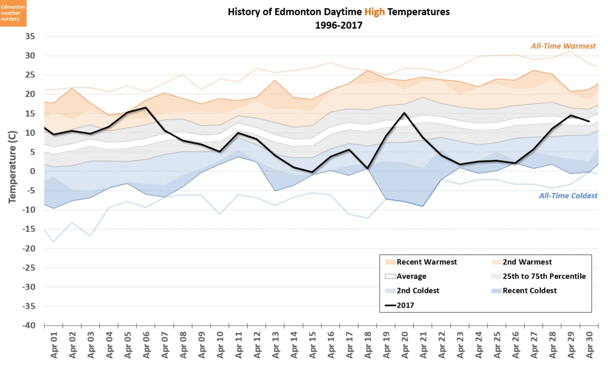
2017 so far...

This chart shows the High temperatures for January through May 13, 2017. We can see all of the wild temperature swings that we've gone through, and it highlights how many days were "close" to the average: whether ±1°C away, ±3°C, ±5°C or ±10°C.

The number of days so far this year that were within 1°C of the average is pretty tiny, with only 10 days scattered over the last 4-and-a-half months. ±3°C from the average puts us at one-quarter of the year, and ±5°C moves us to about one-half. Days that are within 10°C of the average captures about three-quarters of the year so far, but we've had several coldsnaps and warmspells which fell outside of that range.

We're only 4-and-a-bit months into 2017 though, so lets take a look back at last year.

2016 Highs

Here we have the High temperatures for 2016, and how many degrees they were away from the recent average.

And the temperatures last year bounced around quite a bit as well. Throughout 2016, 13% of the daytime Highs were within ±1°C of the average, and most of those were right in the middle of summer. For ±3°C it was 37%, for ±5°C it was 56%, and ±10°C was 87%. But to cover 100% of the days - from the May heatwave to the December coldsnap - we have to go all the way to ±18°C.

To dig a little deeper, lets focus on one slide from that animation:

±5°C from Average

Here are the days last year which were ±5°C from the average. 

A range of ±5°C from the average covers 56% of the days from last year. But in the Summer months 84% of days were in that range, while in the Winter it was only 38%. And that's because our range of potential temperatures is much smaller in the Summer than it is during the Winter. A summer day might be anywhere from 10°C up to 35°C, while in winter it could be -30°C to +15°C.

I don't usually talk about Standard Deviation on this blog, but today we'll make an exception because it's really a perfect demonstration of this:

Standard Deviation Throughout the Year

Standard Deviation is a measure of how variable a set of numbers is, and how far they are from the average. In Edmonton, that temperature variation gets much smaller as we move from the Winter into the Summer.

Based on data from 1996-2017, during the winter the standard deviation for our High temperatures is about 9°C. And so about 68% of winter days will fall within ±9°C of the average, and 95% of days will fall within ±18°C.

For the summer though, the standard deviation for Highs drops to about 4°C. And so 68% of the time we'll be within ±4°C from the average, or 95% of the time within ±8°C. For Low temperatures it's even smaller, dropping to about 2.5°C for June through September.

Intuitively this makes a fair bit of sense. If our average temperature in January is around -5°C, then in a typical winter we will certainly bounce up or down 15°C with chinook-days of 10°C or deepfreezes down to -20°C. On the flipside, during July the average is about 23°C, and we've never recorded a single day 15°C above that, at 38°C.

Anyway, that's enough stats.

So far we've looked at the first few months of 2017, and at all of 2016. But how do things compare over the longer term?

Highs for 1996 to April 2017

Here we are looking at each year going back to 1996, and at how much of it was in the range of ±1°C from the average, ±3°C, ±5°C, ±10°C and beyond.

From this chart, you can see roughly how warm or cold a year was based on how high the bar sits. 2015 and 2016 were both warm, so they are up above the 60% mark, meaning they were above average more than 60% of the time. And as we've seen previously, 1996 was one of Edmonton's coldest years since the 1950s, so it drops down below -60%. The more typical years sit balanced somewhere between +50% and -50%.

When we looked at 2016 we saw that 13% of the year was within ±1°C of the average. For all of the years that increases to 14%. And it's pretty consistent, because the lowest year was 2002 at 10%, and then there are 5 years at 16%.

For the ±3°C range it was 37% for 2016, compared to 38% for all these years. 2002 is again the low year at 33%, and for 2007 44% of the year was within 3°C of the average.

Moving on to ±5°C, 2016 was 56% compared to a recent average of 58%, with 2002 at 48% and 2007 at 65%.

And finally, for ±10°C 87% of 2016 was in the range, the average is 88%, 2009 is the low at 83%, and 2012 is the high at 92%.

So even though 2016 was a fairly warm year, the amount of time that it spent near the average temperatures was fairly average. 2017 looks a little different from all of the rest, but that's because right now we only have data from the erratic winter and early-spring, and we're missing the summer months with their tiny temperature ranges to balance things out.

Another way to look at this is as a breakdown of all the days:

Distribution of Highs

With this chart we lose track of the individual years, but we do get to see how things have generally been distributed over the last 2 decades.

This is broken into summer (April-September) and winter (October-March). For the summer Highs the numbers are nicely centered around ±1°C, and they stretch from 16°C below-average to 17°C above. The winter Highs have a much longer tail - stretching from 27°C below-average to 20°C above - and are skewed so that Highs of 4°C or 5°C above the average are actually the most typical.

Now lets take a quick look at the Low Temperatures. We'll just zip through these, since it's the same basic idea.

2017 Lows

So far in 2017 the Lows have also swung around pretty wildly, and the coldsnaps and warmspells are easy to spot in this chart. But when we looked at the Standard Deviations earlier, we saw that Low temperatures are actually a little bit less variable than the Highs, and we see that here too:


For each of these ranges, more Lows are closer to the average than the Highs were. So for the ±1°C days which are basically right on the average, there were twice as many Lows as Highs. And as we move up to ±3°C about 10% more Lows fell in that range than the Highs, and that continues for ±5°C and ±10°C.

In particular, the Lows for April of this year were very close to average, mostly sitting within ±3°C. But everyone will remember April as being a cold month, because the Highs were sitting around 10°C below average for several weeks.

Lows for 1996 to April 2017

Finally for today, this is the breakdown for the Lows going back to 1996.


And similar to what we just saw for 2017, the Lows are a little bit closer to the average than the Highs, which isn't surprising knowing that the standard deviations are lower. The Lows are right on the average about one-fifth of the time, within 3°C half of the time, and within 5°C three-quarters of the time.

Distribution of Lows

Here we have the distributions again, for Lows during the summer (April-September) and winter (October-March).

The summer Lows are centered on ±1°C, and range from 13°C below-average to only 10°C above. That very small range of temperatures matches what we saw with the standard deviations earlier. The winter Lows are more spread out, from 25°C below average to 17°C above.

Summary

So how close are our temperatures to the average?

Throughout the year we are within 1°C of the average about 15~20% of the time, which I guess isn't too bad? But that depends a lot on what part of the year it is. In Summer 80% of the days are within ±5°C of the average, but in the Winter that range doubles to ±10°C.

In the middle of winter no one wants to hear a forecast that "tomorrow will be 10°C below normal." But the truth is that it is perfectly normal for about one-fifth of the winter to be 10°C from the the average (sometimes below, but sometimes above).

So while "normal" is a term that weather-people have borrowed from statistics, it's not great. The temperatures are "average" sure, but they're not really something you should expect on a daily basis.

2017/05/06

Record Watch: May 5th

Yesterday we broke an all-time record at Blatchford:


With a High of 28.9°C we beat the previous record of 28.3°C set in 1911. And the Low of 13.2°C was also the warmest-ever Low, beating the previous 12.8°C from 1957.

First Week of May

For the first week of May we've now set records in 2013 (May 6), 2016 (May 3 & 4) and 2017 (May 5).

On May 4th this year we also reached 24.4°C, but it doesn't quite make it into the Top-50 for this week, because it's in an 8-way tie for 51st warmest.

With these warm days to unofficially start the summer, there is one caveat to keep in mind:

2016

Last year we set two all-time records during this week of the year: May 3rd at 30.0°C and May 4th at 28.8°C, and May 2nd and 7th were also both above 28°C  . But that May heatwave wasn't followed by a particularly hot summer. May 3rd was the warmest day last year, and the rest of the summer had only a few more 28°C and 29°C days in June and July.

2017/05/03

Another Warm First Week of May?

The forecast for the next few days is looking pretty warm, but it turns out that the exact same thing happened last year. So I've now been doing this blog for long enough that today I get to plagiarize myself.

Here is the history of the 50 warmest temperatures for the first week of May:


The all-time records for this week are quite warm - from 26.7°C for May 1st up to 30.3°C for May 6th.

Last year we set two records, on May 3rd and 4th, and were also in the top-50 on the 2nd and 7th.

This year, to break into the top-50 we need to hit 24.4°C, and according to the forecasts it sounds like that will probably happen. And if we do actually reach 27°C this Friday that would put us in about 3rd or 4th place for May 5th.

2017/05/01

April Review / May Preview - Part 2 - Precipitation

In Part 1 of the April Review we looked at the cool temperatures last month. Now in Part 2 it's time to recap April's notable precipitation.

Snow + Rain

In the past few weeks I was updating this chart constantly, as April kept getting soggier and soggier. But here is the final version, showing the Snow and Rain totals for the month.

With 43.2cm of snow 2017 just crept in as snowiest-ever April at the International, barely beating out 2002 at 43.1cm. And 29mm of rain put 2017 as the International's 6th rainiest April.

Adding those up gives 72.2mm of Rain + Snow, making 2017 the International's soggiest April, well ahead of 2nd place 1990 with 60.6mm.

For the rest of the charts today we're going to narrow the timeframe, and just look at the more recent years going back to 1995.

Days with Precipitation


In Part 1 we saw that April 2017 was cold, but it wasn't really cold. It still had a lot of people grumbling though, and I think this chart had a lot to do with that.

In April 2017 we had 16 days with precipitation, which is about double the average for April. 16 days wouldn't be unusual during our July monsoon season, but during July a lot of our rain comes as evening thundershowers, so you don't necessarily notice it as much. But April 2017 was pretty cold, as well as pretty gloomy.

Total Precipitation


Comparing April's total precipitation to other months, with 69mm we were well above the average for April, and roughly inline with June.

I've included 2016 in this chart as a reference, because last year started out so dry - including the fire in Fort McMurray, but also firebans throughout the province. In 2016 Edmonton didn't get any significant precipitation until the very rainy Victoria Day weekend.

(and just a note that Environment Canada's Total Precipitation measurement is a little bit different from Rain + Snow, which I talked about here. But April 2017's 69mm is still well ahead of 2nd place 1990 with 61mm.)

Rain


Here are our rain totals so far for the year, which give us an idea of what we have to look forward to.

29mm of Rain is a lot for April, but recently in 2010 we had 36.8mm, and the all-time record was 49.2mm in 1990. And to put things in perspective, last April we barely got any rain, but then in May we had 107mm.

But of course rain wasn't the only precipitation that we got this April:

Snow

As we saw earlier, with 43cm of snow, 2017 just barely snuck in as the snowiest April ever recorded at the International. It was also the snowiest month of the winter of 2016-2017 by far, making up 31% of our total for the winter.

Looking at 2015-2016, the snow totals were very similar during the middle of winter from November through February. But 2016-2017 started off strong with a snowy October, and finished with a very snowy March, and then the record-breaking April.

Total Snow

When we add all of the snow for the winter together we get this.

The snowy October pushed us up above average to start to start the winter off, but then for most of the winter we were a little below average. March gave us a boost up though, and then April pushed us up to the 75th percentile.

2015-2016 is included as a comparison again, and it spent the whole winter hanging out around the record-lows.


With 139cm so far, 2016-2017 is right around the recent average. In recent years 2010-2011 and 2013-2014 all crossed the 150cm mark, but we're nowhere close to a really snowy year like 2002-2003 which had 225cm.

Snowdepth

And now the final word on snow (at least until next month...)

Even though 2016-2017 ends up being a reasonably snowy winter, we were on the low-side in terms of snowdepth. Two-thirds of our snow came during the relatively warmish months of October, March & April, and that melted pretty quickly. During the middle of winter the snowfall was below average, and we also had a few solid chinooks in January and February to keep things from building up.

Blatchford

And finally for today, we'll take a quick look at Blatchford. Normally for precipitation I use Environment Canada's measurements from the International Airport, because the data there is better. But for a truly historic perspective, we need to go back to Blatchford.

In April 2017 Blatchford measured 69.8mm of precipitation. We don't know how much of that is Rain vs. Snow, because unfortunately they stopped recording that in 2007. But going back to 1881, that's enough combined precipitation to put April 2017 in 3rd place, just behind 1948 with 72.4mm, but well below 1955 with 88.1mm.

So April 2017 is one for the record books: the snowiest April at the International, the soggiest April at the International, and the 3rd soggiest April at Blatchford.

April Review / May Preview - Part 1 - Temperatures

And that's the end of April, 2017.

So just how cold was it, really?

High Temperatures

Here we have the High temperatures for the last two months, how they compared to the records, and how much time we spent above or below the average.

Early-April feels like it was a long time ago now, and it's easy to forget that the month actually started off quite warm. On April 5th we hit 15.3°C which was the warmest April 5th that we've had recently, although still well below the all-time record of 22.2°C from back in 1905. April 6th was a bit little warmer than that at 16.5°C, which was the warmest day of the month.

Later in the month we were pretty solidly below the average, and had two coldest-recent days, on April 18th and 26th.

Let's take a closer look at the numbers:


With an average high of 8°C, 2017 is certainly in the lower-tier of recent Aprils. April 2013, 2011 and 2008 were all about this cold, and 2002 was even colder.

15-of-the-last-20 Aprils have had at least one day above 20°C, but in 2017 we didn't get any. We also only had 3 days above 15°C, and two of those were way back at the beginning of the month. We only had one High below 0°C though, unlike 2002 and 2008 which both had daytime Highs down around -10°C.

Other Cold Aprils

For comparison, here are the temperatures from some of the other cold, recent Aprils:
  • 2013 started and ended colder than this year, and in the middle was pretty similar.
  • 2011 was pretty similar - a little colder at the beginning, and a little warmer near the end.
  • 2008 dipped to some all-time lows around April 20th. 
  • And 2002 started much colder than 2017, but then the last 3 weeks were almost a perfect match to what we've just seen.
I don't have any particular recollection of those Aprils, but I assume people were as eager for spring to get started as they were this year.

Low Temperatures

Compared to the High temperatures, the Lows this month were pretty boring.

At the beginning of the month we were close to a few recent warmest nights, but later in the month we just hung around slightly below the average. And then right at the end of the month on April 30th we had a warmest-recent Low at 5.8°C.


This April there were 15 Lows below freezing, but only one of those was below -5°C. That's quite a bit warmer than 2002 and 2008, which both had 5 Lows below -10°C. The average overnight Low of 0°C for the month puts 2017 right in the middle of recent Aprils.

May Temperatures

As we head into May, temperatures should take another step up (although I said the same thing about April...).

Since 1998 we haven't had a day in May which didn't at least break the freezing mark - the coldest were a few daytime Highs around 1°C back in 2003. Based on previous years we should see a week or two above 20°C, and about three-quarters of the time at least one day in May will hit 25°C. A 30°C day even happens about one-quarter of the time, most recently in 2016 and 2013.

For Low temperatures, about a quarter of the time May will have no lows below 0°C, although more typically there are a a handful. In recent years the coldest May nights were -6°C, back in 2002.


Finally for today, here's the latest topographical representation of the last 20 years of Edmonton High temperatures. I've been doing these for the past few months, and with the addition of May we see the temperatures continuing to rise, and the overall landscape continuing to flatten out with less wild variations. I know this thing doesn't make a lot of sense, but in a few weeks I'll look at it in more detail, to try to give it a bit more context.

That's it for today's look back at the temperatures of April, 2017. The big story this month was actually probably precipitation, and we'll be back to look at that later in Part 2.