2018/11/30

November Review / December Preview

Personally, November is probably the month that I fear the most, because you never know if you're going to get 5°C or -25°C. Lets see how scary November 2018 actually was.


High Temperatures

The start of the month was not very encouraging, with a week of Highs well below average. But after that cold start the temperatures warmed up, and the last 3 weeks of the month were 10°C to 15°C warmer than the first week was.

We didn't set any all-time records this month, but November 6th & 7th were the coldest since 1996 at -9.9°C and -5.7°C respectively. And then November 14th was the warmest since 1996 at 10.6°C.

The last week of November was pretty pleasant, and it had me wondering how often we have temperatures above freezing right at the end of November:


Looking at the orange boxes in this table we can see that a warm final week of November is actually pretty common - 2018, 2017, 2015, 2011, 2009, 2008, 2004, 2002 and 1999 all had days above 5°C.

In the writeup last month I had said that it wasn't unusual for November to have 20 days with Highs above freezing. At the start of this month that didn't look like it was a good bet to make, but by the end we'd hit 19 days above 0°C. That isn't a lot compared to 2009 which had 30 days and 2008 which had 28, but it's not bad.

On the cold side of things we didn't have any Highs below -20°C, or -15°C, or even -10°C. That isn't rare, but it's a bit uncommon with 2015, 2009, 2008, 2004 and 1999 as the only other recent years to do that.

The average High for November 2018 was 1.7°C, and that is right around the middle of recent years. In comparison though, November 1918 is on the far right side of the chart, and the average High a century ago was a balmy 3.9°C.


Low Temperatures

For the Low temperatures at the start of the month we were right at the bottom of the recent (since 1996) range, although that's still 10°C or 15°C warmer than the record Lows. And as we saw with the Highs, after that cold first week things warmed up, and mostly stayed well above average through the end of the month.


Our average Low of -6.2°C was right in the middle of the range for recent years. We had 2 days with Lows below -15°C which is on the warm side of things, and we didn't have any -20°C Lows, which happens about half of the time.


Warm & Cold Novembers

When we add up the Highs & Lows the average temperature this November was -2.2°C, which made it the 53 warmest November since 1880. In terms of Highs it was the 56th warmest, and for Lows it was the 43rd.

So this was an above average November, but it was not particularly unusual.

The dotted red lines in this chart show the 10-Year average Highs, Lows, and Means for November, and as we saw a few weeks ago in The Months through the Years Edmonton's temperatures during November haven't warmed up all that much over the years.


For 2018 so far then, November is the 6th month that was warmer than the 20th Century average, versus 5 months which were cooler. At the end of December we'll do the full 2018 temperature report card to see how it ranked overall - for now lets just say that 2018 has not been a particularly warm year overall.


Comparing November 2018 to other recent years it wasn't as warm as the very warm November 2016, and it was a little cooler than 2015, but it was warmer than every other November back to 2009.  But Novembers in general just haven't seen the more extreme changes of January and February.


And this chart just gives Edmonton's recorded history of warm and cold months.


Precipitation

In November the International recorded 26mm of Precipitation (rain & snow). That's a bit more than the average of 20mm and last year's 20mm. Blatchford only recorded 15mm, although it also had a few days of missing measurements.


Rain

We don't necessarily think of November as a rainy month in Edmonton, but it's actually fairly common, especially in the first half of the month. This chart shows how often the International Airport has had November rain since 1995.


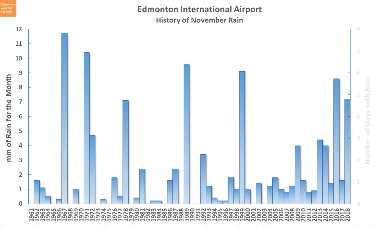
Totaling the November rain up for each year, in 2018 we had 6 days with rain and a total of 7.2mm. The average is about 2 days and 2mm, so this year was above average.


Snow

In terms of snow November 2018's 17cm was just a bit below the average of 20cm, and just a bit below last year's 19cm. And that was above the 8cm we got in October this year, but well below the ridiculous 38cm in September.

Typically November, January and March are our big snow months, all averaging around 20cm. December is a step below that, and then February and April are another step down.


For the winter so far our total snow is 64cm. That's well above average, thanks mostly to our ridiculous September.


Snowdepth

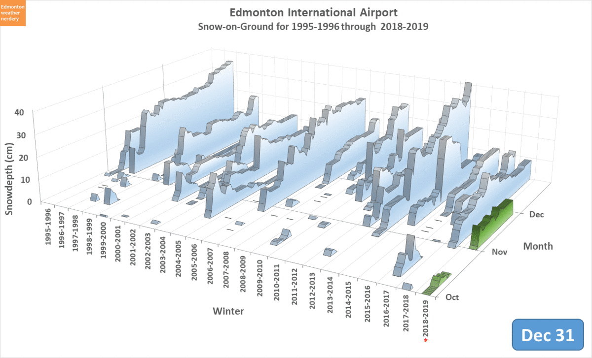
Here is the snowdepth at the International so far this year. Our early October snow hung around for quite awhile before finally melting off. And then we got another blast of it at the beginning of November.


The warm temperatures at the end of November seemed to melt a lot of snow inside the city, but at the International the snowdepth has held pretty constant at 7cm.


...and since that pesky snow hasn't melted, I think we will make the official call that the first "lasting" snow of the winter of 2018-2019 was on November 1st. That's one day later than last year's October 31st, but both of these last two winters were pretty early. The also both had very early first snows, way back in the 2nd and 3rd weeks of September.


December Temperatures

For December, on average we have 10 days with Highs above 0°C. But that average is a bit misleading, because there were a bunch of years with more than 15 days above freezing (2017, 2011, 2006, 2005, 2004, 2003, 2002 & 1999) and then a bunch of others with 6 days or less (2012, 2010, 2009, 2008, 2007, 2001, 2000).


For the Lows, in the last 19 years there have been 2 December which didn't hit -20°C, and 11 which didn't hit -25°C. So that's something, I guess?

As a reminder of last December, it was incredibly warm right up until Christmas Eve, and then we were slammed with a deep freeze that lasted into the first week of January.

2018/11/21

Grey Cup Weather History

An outdoor football game in Canada at the end of November might not sound like the wisest idea, but the Grey Cups which have been held in Edmonton have been reasonably mild:


Prior to 2018 Edmonton has only hosted 4 other Grey Cups, and so this chart also includes the 2003 Heritage Classic Oilers game which was also held outside at Commonwealth Stadium in late November.

The Grey Cups have been pretty warm, with Highs between -3.1°C and -7.8°C, and the Lows from -15.5°C to -9.8°C.

In comparison the Heritage Classic was really cold, with a High of -17.9°C and a Low of -25.2°C.

These games range from as early as November 16 to as late as November 28, and for that time of year Edmonton's average Highs are roughly -2.5°C and the Lows about -11°C. So the Grey Cups have been right around or just below average, while the Heritage Classic was 15°C below average.

We would normally also do a Precipitation chart, but it's pretty boring: the 1984 Grey Cup recorded 0.2cm of snow at both Blatchford & the International; and the 1997 Grey Cup recorded 0.2cm of snow at Blatchford.

Updated for 2018:

And here are the updated temperatures, including for the 2018 Grey Cup.

Even though November 25th is pretty late in the year, this was a pretty warm day with a High of +4°C and a Low of -4.9°C.

2018/11/15

The Months through the Years

The title of today's post is not great, but we're going to be looking at how the temperatures for each month of the year have changed since records began. And thus: "The Months through the Years."

It goes back to this chart, which we saw last month in the October Review / November Preview:


There are quite a few things going on here:

  • The average Daily Mean temperatures (average of the Highs & Lows) for each October are the orange & blue bars. October 2018 ranked as the 92nd warmest since 1880.
  • The average Daily Low temperatures are the blue line - 2018 ranked 86th.
  • The average Daily High temperatures are the orange line - 2018 ranked 89th.

At the end of this animation the 10-Year Averages for the Low, Mean, and High appear as dotted, red lines. Those averages show how temperatures have changed over time, and they are what we're going to be talking about today. For October the average Low has risen from about -2°C to +1°C, but the average High has actually fallen from 12°C to 10°C. That last part seems weird.

Let's get started with a quick recap of Edmonton's temperature history:


Warm Years

We use this chart quite often. It shows how the average temperature for each year compares to the 20th century average. Back in the 1880s the temperatures here were 1°C or 2°C colder than the 20th century average, but since about 1975 most of our years have been 1°C or 2°C warmer than the 20th century average.

The numbers in this chart are for an entire year - they are the average of the Highs & Lows for all 365.25 days. But when we break that down a bit we will see that some parts of the year have changed more than others.


Warm Months

We've used this chart in the past too, and it shows how warm each month is, compared to the 20th century average for that month. This lets us see 20 years at a time, and over on the far right is the average for those 20 years. As this animation cycles through from the 1880's to today we can see how that average has changed from colder (blue) to warm (orange).


To make things simpler, here is the first slide of that animation which covers 1880-1899.

130+ years ago there were some warm months - notably January 1889 was 8°C warmer than the 20th century average, and November 1890 was 7°C above. But there were also some really cold months, with December 1880, January 1886, February 1887, and November 1896 averaging 11-14°C below the 20th century average.

When we look at the "20-Year Average Difference" column on the far right we can see that for this time period all twelve months of the year were below the 20th century average. January & February were the most below at -2.3°C and -3.1°C, whereas April & December were both only a little bit below at -0.3°C.


And in comparison here we have 1999-2018. There are still some blue bubbles here for cold months, with the most below-average month being March 2002 at -7°C. But just generally there is a lot more orange on this chart than what we saw for 1880-1899.

Looking at the "20-Year Average Difference" again:
  • The late-winter months of January & February have seen big changes in recent years, averaging 4.3°C and 2.4°C warmer than their 20th century average.
  • The early-winter months of November & December are only 1°C and 1.2°C warmer, which is about the same change that the summer months of June-September have seen. 
  • The shoulder-season months of April & October have actually been a little bit cooler than the 20th century average.

Even with plenty of variation year-to-year and month-to-month, January and February are where we've seen the most consistent and the largest changes. From the 1880's to today January's average temperature has increased by 6.6°C and February's has increased by 5.5°C. The next largest is March with only a 2.3°C change.

For this chart we are using the Monthly average of the Daily Mean temperature, which is the average of the Daily Highs & Lows. Next we are going to split the Highs & Lows up to see how they behave separately.


Monthly Lows

This chart cycles through the average Low temperature for each month of the year, with the history going back to 1880. The dotted red line is a standard best-fit trendline.

For all 12 months of the year the Low temperatures are trending upwards, although there is a lot of variation:

Monthly Average Low Temperatures


1880s
2010s
Change/Century
January
-21°C
-15°C
5.3°C
February
-19°C
-12°C
5.5°C
March
-12°C
-7°C
3.8°C
April
-3°C
0°C
1.7°C
May
3°C
6°C
2.5°C
June
7°C
11°C
3.2°C
July
9°C
13°C
3.3°C
August
8°C
12°C
3.3°C
September
3°C
7°C
3.1°C
October
-2°C
1°C
1.9°C
November
-10°C
-7°C
1.8°C
December
-16°C
-13°C
1.5°C

We don't normally use tables at Edmonton Weather Nerdery, but it's probably the easiest way to talk about this.

The Lows for January & February have changed a lot, trending upwards at more than 5°C per 100 years. March and the summer months have all increased at around the 3°C range. And then April and October-November have been more sedate, averaging 1.5°C-1.9°C per century.

The slopes of the various trendlines in this chart really make the differences between the months apparent. But normally we try not to use trendlines, because they imply that you can extrapolate into the future, even if that might not be appropriate. As an alternative to the trendlines, here is a different approach:


This chart is not as pretty unfortunately, but this uses the 10-Year average Low for each month instead of trendlines.

It tells a similar story to what we just saw above, albeit this time in a more wobbly fashion: January & February have increased a lot, May-September have a visible upward trend, and the rest of the months are a little flat-ish.

We've looked at the Daily Mean temperatures and the Daily Low temperatures, and so now all that's left is:


Monthly Highs

In this chart we've moved on from the Lows to the Highs, and the thing to notice here is that not all of the trendlines are sloped upwards:

Monthly Average High Temperatures


1880s
2010s
Change/Century
January
-10°C
-6°C
3.1°C
February
-7°C
-3°C
3.0°C
March
1°C
1°C
0.3°C
April
11°C
10°C
-1.0°C
May
18°C
18°C
-0.3°C
June
21°C
21°C
0°C
July
23°C
23°C
0.1°C
August
22°C
22°C
0.3°C
September
17°C
17°C
0.3°C
October
11°C
10°C
-0.7°C
November
1°C
1°C
-0.3°C
December
-6°C
-6°C
0.1°C

Again, January & February have had the biggest changes with average High temperatures increasing by about 3°C per century. The summer months have also trended upwards a little bit. But for the shoulder-season months the average Highs have actually fallen by -1°C for April and -0.7°C for October.

(if you've noticed that the numbers in these two tables don't add up to the bubblechart that we started with, there are two reasons for that: 1) the bubblechart used a 20-Year window while the tables use 10-Years; and 2) the tables use the best-fit line which isn't a perfect match to the measured data.)

Switching from trendlines to 10-Year averages again:


And this is similar again, with the Highs for January & February noticeably increasing, while the rest of the months look pretty flat.


The Yearly Rollercoaster

This is another way to look at things.

In this chart the blue and orange background is the range of our yearly Low temperature rollercoaster, for 1996-2018. The white line running through the middle is the recent average Low for each day of the year. The red line that appears is the average Low for 1880-1899.

For almost the entire year the red 1880-1899 line is shifted down from the white recent line, with really large gaps in late-January, early-February, and late-November. But for a few parts of the year - early-March, mid-April, late-November and early-December - the historic average Lows are very close to modern temperatures.


When we switch this chart to compare 1880-1899 average Highs the differences are less clear.

Again, there is a big gap between the red & white lines in late-January and early-February, where the High temperatures today really are 5°C warmer than they used to be. But for the rest of the year the lines are very close to one another. In April the lines look about even, but for October the red historic line is noticeably above the white modern line.


The Shoulder Season

So lets take a closer look at April & October:

April
October

With both April & October the Lows have increased by about as much as the Highs have decreased.

Those two months have something else in common:


On the yearly temperature rollercoaster April and October are mirror-images of each other. They are the two months where the temperatures are changing the fastest - from winter into spring, and from fall into winter.

But why have the average Highs nudged down over the years? No idea. That's outside the scope of mere weather nerdery, and it would need to be left to the real climate scientists out there.


December vs. January

We're going to finish today by taking a look at two neighbouring months who haven't been following the same path.

December

December's temperatures haven't changed very much over they years. The average Daily mean has hovered around -10°C, with the average High around -6°C or -7°C, and the average Low warming up a bit from -16°C to around -13°C. 

January

January is a different story, with the Highs, the Lows, and the resulting Daily Means all jumping up by more than 5°C.

And that means that January is no longer Edmonton's coldest month:


January used to be Edmonton's coldest month by far, with average Highs 5°C colder than February & December, and Lows 4°C below February and 5°C below December.

But because in recent year January & February have both warmed up so much they've passed December, putting it in coldest-spot for both Highs & Lows. The fact that our winter bottoms-out in December is something that we saw in Are we there (the middle of winter) yet?


Summary

In previous posts we have seen that Edmonton's recorded temperatures have been warmer recently than they were a century ago. We've also looked at nearby rural stations and to other Canadian cities, and have seen a similar pattern.

When we dig deeper into Edmonton's temperatures we see that the changes have been concentrated in January & February, with large increases in both the Highs and the Lows. The summer months and November & December have seen small increases to the average Lows, but the average Highs have been relatively unchanged. And for the shoulder-season months of April & October the average Lows have also increased a bit, but that has been offset by a decrease in the average Highs for those months.

And in general all of that goes back to something that we saw in one of Edmonton Weather Nerdery's earliest posts: Edmonton might not be getting much warmer, but it has been getting less cold.