2018/12/31

First -20°C of the Winter of 2018-2019

It had to happen eventually.


Earlier this winter we did hit -18°C on December 7th, and -18.4 on December 26th, but December 30th is our first, official -20°C.


December 30th is quite late for our first -20°C, and last year was also quite late on December 24th. In 2016 it was a few weeks earlier on December 7th, and the 6 years from 2010-2015 all had their first -20°C days in November.

Since 1880 the "average" day of the first -20°C has moved around a bit: in the 1880s it was late-November; in the 1930s it was up around mid-November; in the early 2000s it was mid-December; and right now our average is the end of November.

Since 1880 there have only been 8 winters where Edmonton made it all the way through November & December without recording a Low of -20°C:
  • 1918-1919
  • 1952-1953
  • 1953-1954
  • 1969-1970
  • 1974-1975
  • 1987-1988
  • 1997-1998
  • 2002-2003

The winter of 2002-2003 was the latest, making it all the way to January 11th.

This chart also shows the date of the first -25°C.

Sometimes -25°C follows right behind the first -20°C, and other times there is a big gap. The largest gap was 1930-1931, with -20°C showing up early on October 19, and then 144 days later -25°C hitting very late on March 11. 1991-1992 was similar, getting it's first -20°C on November 1, and then -25°C arrived 110 days later on February 20.

There was one winter in Edmonton that did not have any temperatures below -25°C, and that 1986-1987.


Coldsnaps

On average we get about 23 Lows of -20°C each winter. That can range from a mild winter like 2015-2016 which only had 6, up to our coldest recent winter 2010-2011 which had 48.

Last winter had a late first -20°C on December 24th, but by the end of the winter it had racked up 31 days at -20°C, which is on the higher side of things. So if we get a late start that doesn't guarantee that the rest of the winter will be warm.

(and for this chart I am assuming the December 31st 2018 is going to have an official Low of -19°C. If it actually comes in as -20°C then we would have 2 -20°C days so far this winter)


Cold Lows Each Month

This chart shows how many cold days we average each month, for both recent years (1996-2018) and the 20th Century.

We mostly made it through November & December without deepfreezes, and right now on-average Novembers have 1.4 -20°C days while Decembers have 6.2. January is the big month for -20°C days though, averaging 9.7, then February averages 4.7, and March drags winter out with another 2.6.

Comparing 1996-2018 to the 20th Century average (which includes 1901-2000, and isn't just for the super-cold 1900ish years) most of the months have dropped by 1/3 to 1/2.

January is also our peak month for -25°C days with 4.9, and -30°C with 1.4. So as we head into January we'll just need to see how it goes.


Cold Lows at the Airport

The airport is quite a bit colder than Blatchford, averaging about 40 days at -20°C each winter compared to the 23 at Blatchford.


0°C Highs Each Month

For cold days there's quite a bit of variation between recent years, and the past, and the airport. But for warm days things are a lot more consistent. Recently Blatchford has had more warm days each winter than it's 20th Century average or the airport, but the difference is usually only 1 or 2 days.


Chance of Extremes

And this chart is one that we looked at back in 'Tis the season of -20°C. And it's just a reminder that we're more likely to have a 0°C High than a -20°C Low at almost any point in the winter, except for the last week of December, and the first two weeks of January.

2018/12/21

Christmas & New Year's - 2018 Edition

In previous years we have split Christmas and New Year's into two separate posts, but this year we're going to combine them, since they are only a week apart and it's interesting to compare the similarities and the differences.

Christmas Day Temperatures

Here we have the High & Low temperatures for Christmas Day, recorded at Blatchford.

2017 was very cold, with a High of -19.3°C and a Low of -26.7°C. That's still much warmer than the coldest recorded Christmases, with the coldest High in 1917 at -28.9°C and the coldest Low way back in 1880 at -39.4°C.

Recently things have been some warm years like 2005 & 2011 with Highs above 6°C; and from 2001 through 2007 all 7 of those Christmas Days had a High above freezing. But there have also been some cold Christmases, like 2008, 2012, & 2017 with Lows down around -25°C; and 2015 & 2016 were also both cool~ish with Highs of -12.9°C and -14.4°C, and Lows of -20.1°C and -22.9°C respectively.

Looking at the lines for the 30-Year averages, right now the average High for Christmas Day is about -4°C and the average Low is -13°C. For 1880-1910 the average High was -7°C with an average Low of -16°C, and the averages were actually lowest around 1940 (covering the period from 1910-1940) with Highs of -11°C and Lows of -18°C.


New Year's Eve Temperatures

New Year's Eve 2017 was also very cold, with a High of -22.6°C and a Low of -28.2°C. That was part of the weeklong cold snap which started on Christmas Eve.

New Year's is only a week after Christmas, but the average temperatures are quite a bit lower: an average High of -4°C for Christmas compared to -8°C for New Year's; and an average Low of -13°C for Christmas compared to -16°C for New Year's.

New Year's Eves for 2014, 2015, & 2016 were all fairly warm though, with Highs of 3°C, 2.5°C, & -1.5°C respectively, and Lows of -3.6°C, -14.4°C, & -9.7°C.

One of the important things about New Year's Eve is always hoping not to freeze at -20°C or -25°C while waiting for the fireworks in Churchill (or at any other outdoor activity). The City cancelled the outdoor activities in 2017 because it was so cold, and in the last decade other cool New Year's Eves were 2008, 2009, 2010, & 2013 all with Lows below -22°C.


New Year's Day Temperatures

Average temperatures for New Year's Day are pretty close to New Year's Eve, with the Highs at -8°C and the Lows at -16°C.

New Year's Day 2017 was the end of the weeklong deepfreeze, with a Low way down at -27.6°C, but then a High of -7.8°C. And then January 2nd hit 3.2°C.


Christmas Eve & Christmas Day Precipitation

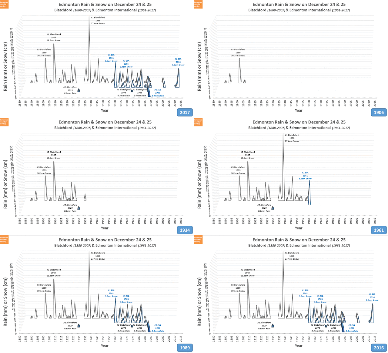
For a holiday like Christmas I think it makes sense to combine the snowfall on Christmas Eve and Christmas Day, so here we have the Snowfall (or Rainfall) for December 24 & 25, for Blatchford and the International.

Blatchford's snowiest Christmas was 1938 with 27.4cm of snow, and the International's was 1961 with 9.9cm. Recently 2016 was the International's 2nd snowiest Christmas with 7.5cm.

Blatchford has recorded rain on 3 Christmases, with 1989 as the rainiest at 2.4mm. And 1989 was the only Christmas when the International recorded rain, also with 2.4mm.


New Year's Eve & New Year's Day Precipitation

And here we have the combined precipitation for December 31st and January 1st.

Blatchford's snowiest New Year's had 15.2cm of snow in both 1893 and 1934. The International's was in 1997 with 11.8cm.

The International has never recorded rain on New Year's, but Blatchford recorded a little bit in both 1958 and 2000.

Jewelry stores used to do a promotion where if it snowed X amount (I can't remember how much) on New Year's Eve or Day (also can't remember which) then anyone who'd bought something during the holiday season would get it for free. Across the two days the most snow we've gotten recently (ie. since the 1930s) was 11.8cm at the International for the 1997-1998 New Year's.


Snowdepth

Snowdepth at this time of the year isn't too exciting, with an average of about 10cm-15cm. But there are big winters like 2013-2014 up at 35cm, and low winters like 2005-2006 down at 0cm.

There's no risk of having a brown Christmas this year, but it almost happened last year, and we did a whole big post about it. The last time that we had a brown Christmas (or low-snow Christmas) was 13 years ago in 2005. But in 61 years of recordings at Blatchford there have been 11 low-snow Christmases (18% of the time), and in 55 years at the International there were 7 (13% of the time). The peak era for low-snow Christmases was 1997-2005, with 4-out-of-9 years recording 1cm-or-less of snow at both stations.

2018 Update:

And so for Christmas Day 2018 the High of -5.3°C was right around the average, while the Low of -10°C was a little bit above average. So a mild day (especially compared to 2017) but pretty typical.


And for Christmas Eve & Day Precipitation the International recorded 2.2cm of snow while Blatchford had 1.6mm of Total Precipitation (environment canada doesn't separate rain & snow at Blatchford anymore, but we'll assume that was snow).

2018/12/10

December Rain

Today we had some freezing rain, so lets take a very quick look at the Edmonton International's history of rain in December:


Going back to 1995 there were 13 days which recorded rain at the International Airport.

The International recorded 2.6mm on December 10th 2018 was the largest rainfall since 1995, beating the 2.4mm on December 20th 1999, and the 2.0mm on December 6 2008.


In the International's history the rainiest December was 1985 with 8.4mm, but 1989 had the most rainy days with 5.