2016/10/31

October Review / November Preview

We'll start this monthly recap a little differently than most:

The Race for Warmest-Recorded Year

This chart is a day-by-day comparison of how warm 2016 has been relative to other warm years from Edmonton's history. It's a bit complicated, and if you're interested in what it all means it's probably easiest to go back to read: How warm is 2016? (September Edition)

2016 had been in the lead since early April, but on October 18 it dropped into a tie for warmest year with 1981. Since then 2016 opened up a slight lead again, so lets take a closer look:


This shows the same information as the first chart, but zoomed in on July through December. We can see that 2016 really nosedived for two weeks in early October, before leveling out again.

All of the red dotted lines are trying to show where 2016 might end up, based on the performance of the last 10 years. To stay in top spot 2016 doesn't have to be hot (20°C in December isn't required) it just needs to be warmer than the average. So if this November-December is as warm as 2011's was then 2016 will take top spot. A repeat of last year would put 2016 in 3rd place, and just below 1981 and 1987. And if the end of the year is pretty average then 2016 would probably still finish around 3rd, while a couple of really cold months could drop it down to 7th or lower.

How did 2016 lose its lead?

Here are the daily High temperatures for the month, and we can really see the coldsnap from October 5th through 18th. In that stretch almost every day was below the 25th percentile and 4 days were the coldest recorded since 1996.

For the whole month, only 7 days had Highs above the 1996-2015 average, and the other 24 were colder than average.


Here's a similar chart, but showing the daytime Lows rather than the Highs. It tells a similar story, with 18 days below the average, but things did pick up near the end of the month.

Looking at December, we can see how much the temperature range starts to spread out during the winter. In September the lows might range from 15°C to -5°C, but in December that spread doubles and can be from 5°C all the way down to -35°C.

20 Years of Temperatures

These tables always have a lot going on, but I like to use them to spot the blocks of colour. For example, it's easy to see that 2003, 2008 and 2015 all had High temperatures above 25°C which are shown in red. Or for 2016, that there was a long stretch of just-above-0°C from the 5th through the 18th.

2016's average High was 6°C which ties for coldest October since 1997 with 2002, 2009 and 2012. But even though the average is the same as those years, in 2016 we didn't actually have any Highs below 0°C (although we also didn't have any above 15°C, which had never happened since 1997).


The Lows are similar, and looking at the beginning of the month we can see the big block of white cells that have Lows below 0°C. Just eye-balling off the table the only comparable stretch was the end of October in 2004.

The average low for the month of 0°C is pretty middle-of-the-road. Even with that stretch of cold days, in 2016 we didn't dip down below -10°C and into the blues like 2002, 2003, 2004 and 2012 all did. But was also only had 1 Low that was above 5°C, which is on the cool side of things.

What can we expect from November?

November

Again looking at the colours as much as anything, we still see a fair number of oranges, for High temperatures above 5°C. But there are also blocks of blue creeping in, including November highs below -20°C in 2006 and 2014.


For the Low temperatures the oranges are pretty much gone in November, and most nights will drop below 0°C. And again we see blocks of blue, with late-November lows below -25°C in 2003, 2006, 2010, 2011 and 2014.

Finally, we'll take a look at precipitation.

Precipitation

Here we have the monthly precipitation numbers for the year. With all of the snow and general gloom we've had this month, October 2016 comes in second place in the last two decades, at just a little bit below 2006.


And for cumulative precipitation for the year 2016 is still above average, and just above the 75th percentile.

2016/10/27

Halloween

This is a few days early, but today we're going to look at Halloween weather.

Temperature History

In recent years the average high has been 4°C and the average low is -4°C.

But look at 1984: a high of -18°C and a low of -24°C. Crazy. And that high temperature of -18°C was lower than the low temperatures of every other Halloween, except for 1991.

Another strange thing is that we haven't had a Halloween above 15°C since 1981. From 1897 through 1981 there were 9 of them, but there haven't been any since. And from 1880 to 1983 there wasn't a low below -15°C, but since then we've had three of them.

Lets take a closer look at recent history:

Recent Temperatures

The 1980s were my peak-trick-or-treating years. They all blur together, but I remember a lot of parkas - parkas tucked under costumes, parkas over costumes, and maybe even a balaclava one year?

Looking at the history, I guess it wasn't really that cold, but 1984 really was that cold. If I was ever forced to wear a balaclava it would have been in 1984. It is worth pointing out that it wasn't just Edmonton: Calgary's high and low were -16°C and -26°C. But just a few years earlier in 1981 both cities recorded 20°C on Halloween, which was Edmonton's warmest and Calgary's second warmest.

I'd said that the 30-year average high is 4°C, but that's not a great representation because the temperatures actually bounce around quite a bit. In the last 10 years we've had: 2 Halloweens around -5°C; 3 around 5°C; and 5 around 10°C. 

And the average low is -5°C, but the breakdown for the last 10 years is: 2 below -5°C, 2 at around -5°C, and 6 above (or right at) freezing.

So most of the time Halloween here is fall-like, with the occasional years edging into wintery. And just in the last 10 years we've been more consistently above 5°C (80%) than in the 1980s (70%) or 1990s (40%).

Precipitation History

This chart of precipitation is more complicated than I'd like, because it's showing a combination of data from Blatchford (solid lines) and the International (dashed lines), as well as for rain (blue) or snow (b&w). So that's why there are so many lines.

Halloween doesn't get precipitation very frequently, but when it does it's fairly evenly split between rain and snow.

1882 and 1999 are the big snow years at about 10cm, and then there were a few more in the 6-8cm range. And the last "big" rain years with over 2mm were back in the 1960s. 

Finally, Environment Canada has a measurement they call "Snow-on-Ground":

Snow-On-Ground

I've never used this before, and the data for snow depth is a little spotty, so I'm not quite sure how much faith to put in it. 

This only goes back to 1955, and in those last 60 years it looks like 2000-2006 was the real stand-out for most consistently snowy: 6 of those 7 years had 2cm or more snow on the ground. And I honestly don't recall that at all. But since then none of the years show any snow on the ground.

2016/10/24

versus - Montréal

It looks like the snow has taken a break for a week, so I'm going to take a break from writing about it too. Instead, today we're going to look at Montreal (for reasons that will become apparent the next time that we look at snow).

In the past I've done comparisons to a few other locations because I find it useful to give some context to Edmonton's numbers. Today's format will be similar: we'll look at yearly temperatures; break those down into summer and winter; and then look at precipitation. For reference, here are the previous comparisons:

As usual I'm using data from Environment Canada because it's easy to download a long, reliable history. For Montreal I'll be using the weather station at Pierre Elliot Trudeau airport which is about 13km from downtown, compared to Edmonton Blatchford which is about 4km from downtown. Montreal had a nice central weather station located right downtown at McGill with readings going all the way back to 1871, but those stop in 1993 so they aren't any help today.

As I've done for the previous comparisons, here I'll be taking my standard rollercoaster chart that shows how Edmonton's temperature varies throughout the year, and overlaying the Montreal data on top of it.

Daily Highs

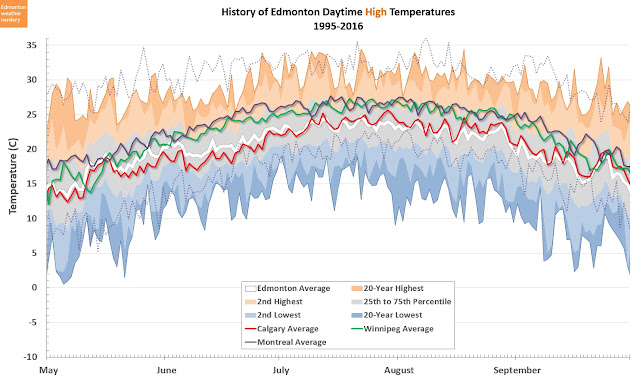
In the background here we have Edmonton's recent history of high temperatures for each day of the year. This a chart that I use all of the time, but it could use some explanation:
  • The white line in the centre is the average temperature based on all of the years from 1995 through 2016.
  • Surrounding that average is a grey band for the 25-75th percentiles, which is where temperatures will fall roughly half of the time. 
  • Finally, the oranges and blues are the warm and cold extremes recorded between 1995 and 2016.
Montreal's daily average is shown in purple, with the maximum and minimum shown as dotted lines.

And for almost the entire year Montreal's average high temperature is several degrees above Edmonton's, but there is a stretch from February through May where they are pretty close. Notably though, October and especially November are much warmer in Montreal than in Edmonton.

Daily Lows

Here we have the daily lows for the year, and again Montreal is well above Edmonton - except for a little window in February and March.

Now lets take a closer look at Summer and Winter, and we'll add in Calgary and Winnipeg for comparison.

Summer Highs

So here we are zoomed in on the daily high temperatures for the summer months. Calgary has been added in red, Winnipeg in green, and Montreal is still in purple.

Winnipeg and Montreal are very close, averaging 3°C to 4°C hotter than the Alberta cities.

One thing I should mention here is humidity - I don't normally talk about it, because I'm from Alberta where humidity is basically a foreign concept. It's certainly not foreign to central Canada though, and the high drybulb temperature that we see for Montreal would undoubtedly be combined with much higher relative humidity than Edmonton or Calgary would ever experience. Environment Canada doesn't include RH in their daily data so I don't have any numbers to compare, but it's just worth pointing that out.

Summer Lows

For the summer lows things shift a bit. Montreal stays about 3°C to 4°C warmer at night than Edmonton and Winnipeg, and Calgary is another 3°C lower than that. The very lowest-lows that Montreal has recorded since 1995 are a little bit above Calgary's average lows, and just a bit below the Edmonton average.

Winter Highs

Things get interesting in winter.

There is a lot going on here, but just looking at Edmonton's average in white and Montreal's in purple, for all of November Montreal averages about 5°C warmer than Edmonton. That gap closes a bit through December. And then starting around mid-January the average high temperatures for the two cities are about the same, and that continues through spring.

While the average high temperatures are close, looking at the coldest days Montreal has recorded since 1995, the highs rarely drop below -20°C while Edmonton has had -25°C and even two daytime highs below -30°C.

For Calgary, in January and February the average high is actually about 4°C warmer than Montreal's or Edmonton's. And Winnipeg is Winnipeg.

Winter Lows

And here are the winter lows.

For all of November the average lows for Montreal are about 5°C warmer than Edmonton, Calgary and Winnipeg. But in December Edmonton and Calgary level off, while Montreal and Winnipeg keep dropping. So by mid-January, the lows for Montreal, Edmonton and Calgary have all synced up, and they stay that way until spring (and again, Winnipeg is off doing its own thing).

But again those are just the averages. Looking at Montreal's very coldest days, since 1995 there haven't been any lows below -30°C, while Edmonton (and Calgary too) have had a few extreme prairie nights below -35°C.

What's interesting here is the distinction between November/December and January/February.  In the depths of winter in January/February the average highs & lows for Edmonton and Montreal are a lot alike. The big difference is that Edmonton gets an extra month-and-a-half of that, because things start so much earlier in November/December.

Precipitation

Finally for today, we'll look at precipitation.


This is Edmonton's yearly breakdown of precipitation, with the Montreal average and recent maximum overlaid on top.

Edmonton's precipitation has a really noticeable peak in July, but that's not the case for Montreal at all. Montreal is very consistent, and most months are at about the same level as the Edmonton peak in July. Montreal's lowest month is February averaging 58mm, and it's highest is December at 98mm. In comparison, Edmonton ranges from 17mm in February to 88mm in July.

And for Montreal's maximum months, outside of June and July all of the others tend to double or triple the Edmonton maximum,

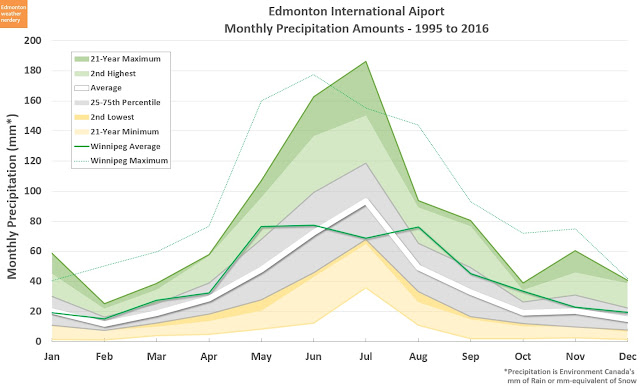
For further comparison, here are the averages for Calgary and Winnipeg added as well:


This is a little messy, but we can see how similar the precipitation distribution is for the three prairie cities - a peak in the summer months and significant drop in the winter - especially when compared to Montreal.

Over the course of a year, here is how all of that precipitation adds up:


Edmonton averages about 425mm of precipitation per year, and the highest recent year was 1996 with 650mm. Montreal completely blows that away, averaging 1025mm per year, and the recent maximum was 1350mm in 2006.

That is just overall precipitation, and we haven't specifically looked at snow yet. Snow is part of the reason that I wanted to look at Montreal in the first place though, and we'll come back to that in the next few weeks.

So for now, I think this is the last of the city-comparisons that I will do. I've got Calgary to show how things can vary within the province, Winnipeg as a representative of a second prairie province, and Montreal is a good stand-in for central Canada.

2016/10/19

This race is all tied up.

Back at the beginning of September I looked at how warm 2016 was compared to the rest of the years in the records:


This chart has a pretty complicated explanation behind it, and if you're interested in what it all means it's probably easiest to go back to read: How warm is 2016? (September Edition)

But the short-version is that this is a day-by-day comparison of how warm or cold each day of the year is. Warm days get points, and cold days lose points. I think the calculation behind it all is pretty fair, and with this approach Edmonton's two previous warmest years were 1981 and 1987. But by April of this year, 2016 had moved into first place, and as of September 1st it was still solidly in the top spot.

Until October...


After the last 2 unseasonably cold weeks that entire lead has been lost, and 2016 is now sitting tied exactly with 1981.

In the next week we'll probably open up a bit of a lead again, because it's finally supposed to warm up, and back in 1981 this week of the year was a little cold. But then in November of 1981 things took off again.

Is there any chance that 2016 will take the top spot by yearend?


In this chart I've added the last ten November-Decembers on as dotted red lines in the upper-right, to show where we could end up.

If the next two months are as warm as they were in 2011, then 2016 would claim warmest-recorded-year. A repeat of 2015's "super" El Niño would put 2016 in contention, but still just a touch below 1981 and 1987. And if we follow any of the other years 2016 could end up anywhere from 3rd to 10th.

Which is not to say that things haven't been warm. For most of the year 2016 has been very warm, and 2015 is the 3rd warmest year on record.


This is the same chart, but the timeframe is shifted so that it compares September 2015 through August 2016 rather than calendar years. I did this back in September when I had first looked at these comparisons, and for that 12-month window (or really any mid-year window before October) 2015-2016 was well above all the rest. But in terms of calendar years at least, it looks like 2016 has probably given up first place.

2016/10/17

136 Years of Snow

We've now had our second major snowfall of the year, and so I guess that it really is time to take a look at Edmonton's history of snow.

As usual when dealing with precipitation, this is going to be a mix of Edmonton Blatchford (data from 1881-2007) and the Edmonton International (data from 1961-present). I never know exactly how accurate Environment Canada's snowfall numbers are, but we're going to be looking at over a century of data, and so even if there is some variation this should at least give us a sense of how things work.

So here are the yearly snowfall totals for recorded history:

Yearly Snowfall

The 5 highest and lowest years for Blatchford are labelled to give some context.

The highest ever was 1935 with 287cm. That was 50cm more than any of the other years, and more than 1m more than we'll see in a typical year.

For the lowest years there are several around the 50cm mark. It's tough to know if those were all truly that low, or if possibly some measurements were missed? But with 5 years all in the same range, and several more around 60cm, that seems to be reasonably accurate as a floor.

Other than the outliers, most typical years are in the 80cm to 180cm range.

Yearly data bounces around a lot, so here is the same data with 5-year averages added on top:

5-Year Average

Here we can see that the average has been reasonably consistent around the 130cm mark, with a few highs and a few lows.

The very lowest years are the 1880s, and once again I have to be a little suspicious about the accuracy of those earliest measurements. Although at the same time, when we looked at first snowfall we saw that the 1880s had several years with very late first snowfalls, so it's possible that those years really did start late, and just didn't get much snow. Or it's possible that they missed some readings. There's no way to tell if it's accurate, but at least it's consistent.

The 5-year averages also make the differences between Blatchford and the International easier to spot. In the mid-1970s the International recorded more snow than Blatchford, but then in the mid-1980s Blatchford recorded more. Generally though, they were pretty similar.

There doesn't seem to be any prominent trend over the last 136 years, so now lets look at more recent history:

Recent History

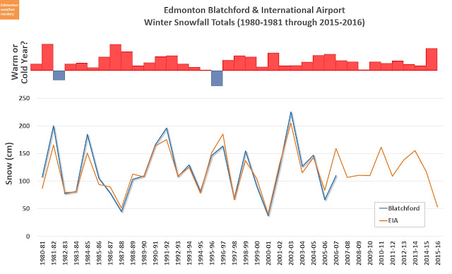
So here we have the yearly snowfall on the bottom, and at the top in the red & blue is the relative warmness of each year (which comes from this post about the 20th Century Average temperature).

We are going back to the 1980s in this chart, because several times on this blog we've seen that the 1980s had some of Edmonton's warmest years. I don't think that people remember them that way though, and in the past I have wondered if maybe the 1980s were really snowy? So that even though they were warm, maybe the snow shaped peoples' perceptions of the winter, rather than the actual temperatures?

But it turns out that, no - the 1980s were not particularly snowy. 1982 was indeed the 4th snowiest year, but then 1987 and 1988 were 5th and 3rd least-snowiest respectively (and 1981 was the least snowy year ever recorded at the International).

I don't want to read too much into things, but Edmonton's #1 and #2 warmest years - 1981 and 1987 - both had very low snowfall at around the 50cm mark. And the two recent years that were notably cold - 1982 and 1996 - were both on the high side of things and approaching the 200cm mark.

Update:

After I posted this, I realized that I was grouping the snowfall by calendar year, although it really makes more sense to look at individual winters instead. Counting things as October-April would be much better than January-April & October-December.

So I'm going to redo this whole post with that shifted perspective.

Snowfall Each Winter - Version 2

With this change our top and bottom 5 have shifted around a bit.

The top 5 are now all in the range of 221-239cm, and for notable recent years 2002-2003 is still in third place.

The very lowest year is 1888-1889 with 23cm, but I'm going to assume that there is a good chance that there are some missing readings there. Next up is 2000-2001 with 38cm, and then several years in the 45-55cm range. Last winter 2015-2016 had 53cm at the International which puts it right in line with the bottom 5.

5-Year Average - Version 2

The averages change a little bit, but not very much. This makes sense, since it's a a 5-year average and we're only effectively shifting things by 6 months.

Recent History - Version 2

This chart of recent history gets a little bit more complicated, because at the top we have calendar years, and at the bottom we have the winters. So the winter of 1981-1982 was pretty snowy, but 1981 was a warm year and 1982 was a cold year - it's tougher to line things up or draw any conclusions (tougher, but I still prefer this approach).

Earlier I'd asked if maybe the 1980s were really snowy? And looking at the numbers this way, the answer is still "not really." 1981-1982 and 1984-1985 were up there, but everything else was pretty unremarkable.

In general then, in the last 35 years we've bounced around in the typical 80cm to 180cm range, with a few 50cm years, and a couple of 200 cm years. And in just the last 10 winters we were consistently right around the 100-150cm range, except for 2015-2016 down at 53cm.

So between these two approaches, I think that breaking things down by winter makes the most sense, since it's what we really experience. And that's how I will handle snow in the future.

2016/10/12

versus - Winnipeg: Part 1

Earlier this summer I did a few comparisons of the weather in Edmonton and Calgary:

Today we're going to look at a third northern, prairie city: Winnipeg.

Winnipeg has two main Environment Canada weather stations: one located at the Forks in the downtown, and the other at the International Airport. That should be a good thing, except that the data for the Forks only goes back to 2000, while normally for these comparisons I've been using 1995 to give a nice 20-year range. But in the interest of providing as complete a picture of Winnipeg weather as possible, today I'll be using both the stations, and we'll only be looking at 2000 onward.

As I did with the Calgary comparisons, here I'll be taking my standard rollercoaster chart which shows how Edmonton's temperature varies throughout the year, and overlaying the Winnipeg data on top of it.

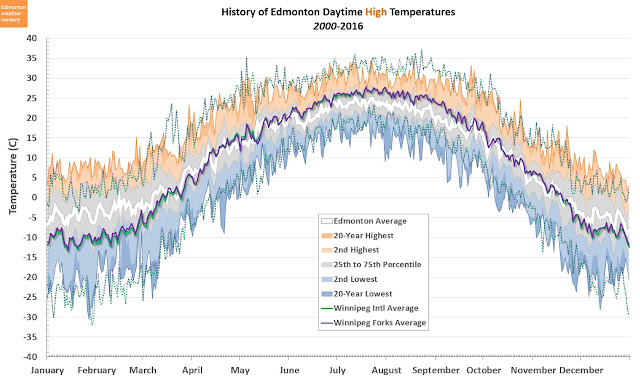
Daily Highs

In the background here we have Edmonton's recent history of high temperatures for each day of the year. It's a chart that I use all of the time, but it could use some explanation:
  • The white line in the centre is the average temperature based on all the years from 2000 through 2016.
  • Surrounding that average is a grey band for the 25-75th percentiles, which is where temperatures will fall roughly half of the time. 
  • Finally, the oranges and blues are the warm and cold extremes recorded between 2000 and 2016.
Data for the Winnipeg International is shown in green, with the maximum and minimum shown as dotted lines. And the Forks is shown in purple, with its maximum and minimum also dotted. In this chart the lines for the International and the Forks are a very close match, so it's actually a little difficult to tell them apart.

We'll look at this in more detail later on, but just generally we can see that in the summer Winnipeg's highs are a few degrees above Edmonton's, and in winter they are several degrees lower. The crossover happens around April, and then again in October.

Daily Lows

Here we have the daily low temperatures for the year, and this one is a little bit harder to read because there is a noticeable difference between the International (green) and the Forks (purple).  For the entire year, the lows at the Forks are consistently a few degrees above the lows at the International.

To make things a little less busy, here are the International and the Forks broken into two separate charts:

Daily Lows - Winnipeg International
 Daily Lows - The Forks


And with both of those charts, the story is similar to what we saw for the high temperatures: in the summer Winnipeg's lows are a few degrees above Edmonton's (or about the same for the International), and in winter they are several degrees lower.

Doing these comparisons in terms of the whole year is a little tough to interpret, so now lets break things down into summer and winter. And we'll add Calgary into the mix as well:

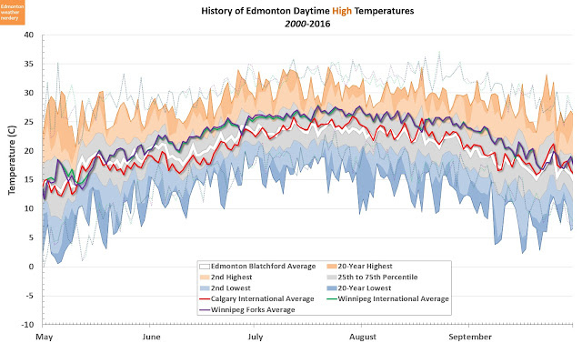
Summer Highs

So here we're focusing on the daily high temperatures during just the summer months. Calgary has been added in red, and once again the highs for the Winnipeg International and Forks are similar enough that it is hard to tell them apart.

Edmonton and Calgary are pretty similar - Edmonton is a little warmer in June, and Calgary is a little warmer in July. But compared to both of them, Winnipeg's summer days are consistently 2-3°C hotter.

Looking at the maximum temperatures for Edmonton in orange, there are plenty of days in July and August where Edmonton has not recorded a temperature above 30°C during the last 15 years. That is not the case for Winnipeg though, where almost every day from June through mid-September has broken 30°C at least once since 2000.

Summer Lows

For the summer lows things diverge a bit. The Winnipeg International and Forks are no longer a perfect match, with the Forks staying 2-3°C warmer overnight. The lows at the Winnipeg International are a fairly close match for Edmonton, and in this case Calgary is a few degrees cooler than all the others.

It's a little tough to see, but Winnipeg's range of summer low temperatures - shown by the faint dotted lines - is quite a bit larger than Edmonton's. In some cases the maximum is 5°C higher, while the minimum is several degrees below. Using mid-July as an example, Edmonton's overnight lows mostly fit in a fairly narrow band from about 10°C to 18°C, whereas at the Forks the range is more like 7°C to 23°C.

Winter Highs

Here we have the winter high temperatures, and again the Winnipeg International and Forks are a pretty close match, with the Forks being just a touch warmer.

Edmonton and Winnipeg are fairly similar through November, but Winnipeg drops off in December, and then again in January. And Calgary is consistently the highest for the whole period.

Just eye-balling off the chart, during the depths of winter in January and February the highs in Calgary average around 4°C warmer than in Edmonton, and Edmonton is about 6°C warmer than Winnipeg. And with that gap, the average highs for Calgary are actually a pretty close match for Winnipeg's 15-year maximum.

Winter Lows

And finally, here are the winter lows.

Here the two Winnipeg stations have separated again, with the International getting about 2°C colder than the Forks. For November and December the Winnipeg lows are fairly close to Edmonton and Calgary, but then things drop off in mid-January. There's a roughly 7°C gap between Blatchford and the Forks, or 10°C between the Calgary and Winnipeg Airports. And that gap hangs around for a long time - almost until the end of February.

In Edmonton, I've come to really appreciate spending time outside in January and February, because compared to November and December things are relatively sunny and warm. But in Winnipeg it looks like January and February are definitely the coldest part of the winter. And looking at the dotted lines for the 15-year minimum, there are some pretty big gaps between the coldest recent days for Edmonton and Winnipeg.

Looking more closely at Winnipeg's coldest temperatures for the past 15 years - the faint dotted purple for the forks, and green for the International - we can see that in January and February there's a significant gap between the two. The International has dropped below -40°C a few times, while the forks has mostly stayed above -35°C.

With these various weather stations, which stations are the "right" ones to compare?

The Forks is right next to downtown Winnipeg, and on the rivers. Comparing that to Edmonton, a similar location would probably be somewhere in Rossdale. But there is no Rossdale weather station, and so instead the Edmonton data comes from Blatchford, which is an airport 4km north of downtown.

Environment Canada doesn't have a central weather station for Calgary, so here I am using the Calgary International airport, which is about 8km north of downtown. And the Winnipeg International Airport is slightly more central than that, at about 7km east of downtown. (I haven't included the Edmonton International, because at 26km from downtown, it plays by its own rules. I did talk about it a bit in the Calgary comparison, though)

So all told, the Winnipeg and Calgary airports are probably pretty good comparisons for one another. If Calgary did have a central station, its low temperatures might bump up by a few degrees, like we see with the Forks. And as a reference point Edmonton Blatchford likely falls somewhere between the two Winnipeg stations.

Precipitation

Finally for today, we'll take a quick look at precipitation. These will be using a few of the standard charts that I have set up for Edmonton, but with data for the Winnipeg International overlaid on top (I'm not including the Forks this time).


Here we have yearly precipitation broken down by month.

In terms of averages, Edmonton and Winnipeg are very similar for November through April. But then it looks like Winnipeg has a really long, consistent monsoon season from May through August, while Edmonton's is really just late June and early July. After July Edmonton's precipitation drops off, while Winnipeg's stays comparatively high through to October.

Breaking it down by month it's tough to see how the two cities compare overall, so here is the yearly data:

This shows how the precipitation builds up over a year. Winnipeg and Edmonton are similar for the first few months of the year, but then in May Winnipeg gets a bump, and after that it stays above Edmonton for the rest of the year. By yearend, Winnipeg averages a little over 500mm, compared to Edmonton's 425mm. I haven't included Calgary here, but it basically matches Edmonton's numbers.

So with all of that said, I'm not sure if there are any surprises?
  • Winnipeg's summers are a few degrees hotter than Edmonton or Calgary.
  • Winnipeg's winters are several degrees colder than Edmonton, which is a few degrees colder than Calgary - in terms of surprises, I guess I wasn't expecting January and February to be quite so different from Alberta.
  • Winnipeg's precipitation is 15~20% higher, which I probably wouldn't even notice.
I've called this Part 1 of the Winnipeg comparison, although I don't actually have a Part 2 planned. But I'm sure that there will be one at some point.

2016/10/08

First Snowfall

I have to admit that I did not believe the forecasts, so I wasn't prepared for this. I figured that all of my blogging about snow was at least a few weeks away.

But since we've now had our first real snowfall, is October 7th actually early?

We're going to take a quick look at the history of Edmonton's first snowfall of each year, with a couple of caveats:
  • This will be "major" snowfalls of at least 1cm. Anything less than that doesn't count.
  • I'm going to use September as the starting point. We have actually gotten snow twice in August (August 25, 1900 and August 21, 1992), but I'm going to skip those. There's never been any snow recorded in July, though.
  • Even by limiting it to September, a lot of these first snowfalls would have melted off again long before the real winter began.
  • This will be a mix of data from Blatchford and the International, because the International only goes back to 1961, and Blatchford's data disappears after 2007

So then, here is the whole recorded history:


This chart is a little hard to interpret - each year is along the bottom, and the date of the first snowfall is along the side. So the higher the line goes the later in the year the snow fell, and the lower the line the earlier the snow.

Blatchford is in Blue from 1882 through 2007, and the International is in Orange from 1961 onwards. The two overlap from 1961 through 2007 and in many cases they match, but there are some years like 1981 where the International's first snow was on October 21 while Blatchford's wasn't until December 10.

Looking at all of the recrods, the breakdown of how often each month gets the first snowfall is:
  • September - 25% of the time
  • October - 46%
  • November - 27%
  • December - 2%
Limiting that to just 1995-2016 it shifts a bit:
  • September - 14%
  • October - 55%
  • November - 27%
  • December - 5%
So October is definitely when this is most likely to happen. And our likelihood of September snowfalls has actually fallen a bit in the last few years.

Here is the same graph, but with a 5-year "average" added on top:


An "average" date is sortof a strange idea, but this just smooths things out a bit and makes trends a little more visible.

What's interesting is that going way back to the beginning, in the 1880s snow generally fell much later in the year? It's possible that's true, but I think it's also possible that it's pretty hard to measure snow depth, and that our methods have improved over the years.

Beyond that, the "average" date has pretty much stayed in October for the last century.

Looking at 130+ years is a little hard to grasp, so now lets focus on more recent history:


This is the graph of the annual dates again, but this time only going back to 1980. Here we can see just how often the dates for Blatchford and the International match, with only a couple of large exceptions like 1981 and 1985.

So how unusual is snow on October 7th?

On this chart there's a dashed line to help compare 2016 to the other years, and in recent memory:
  • 2014 had 4cm on September 8, and 2004 had 5cm on September 9th
  • 2012, 2009, and 2002 all had snow right about now.
  • Everything else was later.

So we are definitely on the early side of things this year. And if you exclude 2004 and 2014 then this is just about as early as we ever get snow.

Here's one final look at the data, with the 5 Year averages going back to 1980:


Back at the end of the 70s and beginning of the 80s there were several years with really late snow, so the average was pushed to almost mid-November. But then right after that 1983, 1984 and 1985 were all in mid-September, and the average dropped down to the end of September. Since then though it's been pretty solidly between Thanksgiving and the end of October.

2016/10/07

Thanksgiving

Another long weekend with a pretty nasty looking forecast:

Source: Environment Canada http://weather.gc.ca/city/pages/ab-50_metric_e.html

How unusual is that?


The average high for this time of year is way up at 12°C, and the low is 1°C. And those are just the averages - last year we had a day above 25°C, and days above 15°C are pretty common.

But if the weekend does follow the forecast, then it will definitely be a cool Thanksgiving. Although we should still be well above 2009 which was the coldest in recent history, where the high temperatures for all 4 days were below freezing.


In terms of precipitation, Thanksgiving is normally pretty quiet.

This year's forecast calls for rain and flurries and snow - and some parts of the province are supposed to get a lot of snow - so we'll have to see where things end up.