Today is going to be a bit of a repetition of some posts from last winter, where we had looked at Edmonton's first snowfall of each winter and when snow starts to hang around.
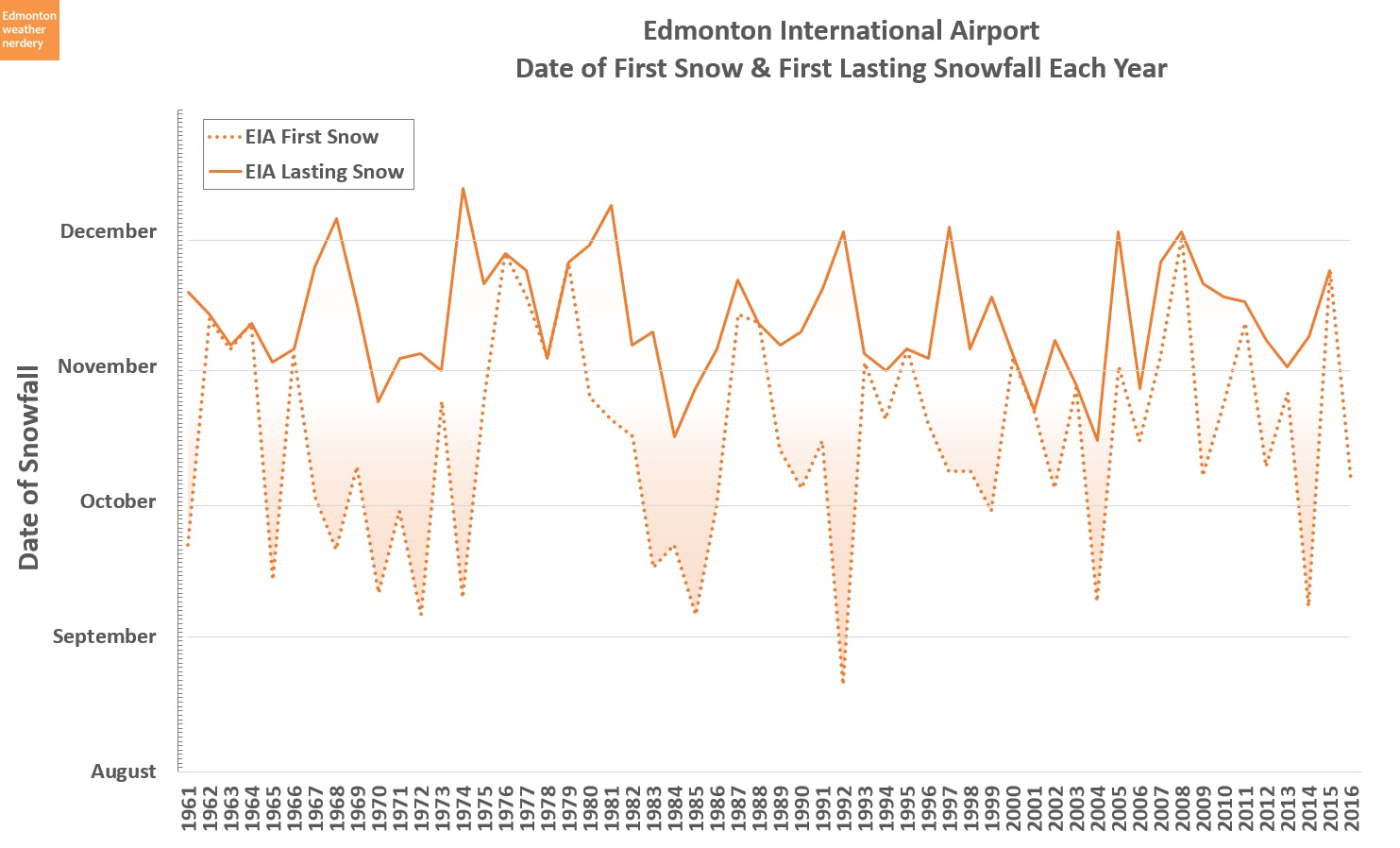
Here's the chart from last year:
First Snowfall versus Lasting Snowfall
With the dashed-line in this chart we can see that the first snowfall usually happens between mid-September and mid-November. In 1992 the airport even recorded 2cm of snow on August 21, but that was unusual. When we get early snowfalls in September and October (or even August) they usually melt-off quickly.
The solid-line in this chart shows when we start to get lasting snow, which is when the airport has a measurable depth of snow on the ground. That doesn't usually happen until mid-October at the earliest, and about half of the time it's mid-November or later.
There have been a few years in which the first snowfall was quickly followed by lasting snow, but sometimes they can be separated by a month-and-a-half. And for the August snow of 1992, the lasting snow didn't arrive until more than 3 months later at the beginning of December.
All of that is covered in greater detail in the original posts, but I always felt like this chart was missing part of the story. So this year I want to try something a bit fancier:
First Snowfall versus Lasting Snowfall - Version 2
This chart starts with the same basic idea - the difference between the first snow and lasting snow. But this also shows all of the individual snowfalls that occur from September 1 through December 31.
The dots in orange are for snow that melts, and the blue dots are for when it starts to stick around. The size of each dot corresponds to the amount of each snowfall, and anything greater than 0.1cm is included here, so some of these are very small.
What I like about this busy animation is that we can see how snow becomes more frequent as we move from fall into winter. In September the dots are rare, but around mid-October they start to appear more often. Things pick up at the start of November, and then by mid-November the snow just explodes.
Simplifying things a bit, this is the same chart showing only the recent years from 1995-2017 (and one version with the animation, and one without).
Since 1995 snow in September has only happened 3 times - in 2004, 2014, and then this year we got a bunch.
And lasting snow has only shown up before Halloween 6 times - in 1995, 2000, 2003, 2004, 2006 and 2013. We looked at Halloween last year and saw that 2000-2006 were the peak years of snowy-Halloweens in Edmonton, which was a bit unexpected.
For first snow, in recent years the most common weeks have been the 2nd and 4th of October. The rest of the years are spread out from the 2nd week of September all the way through the 1st week of December.
For lasting snow the 4th week of October and 3rd week of November have been the most common, each with 5 years. Broken out by month, lasting snow has happened in October 6 times, November 13 times, and then 3 times in December. In total though, it means that since 1995 lasting snow hasn't shown up until after Halloween 72% of the time.
Picking the exact date of "lasting" snow is a bit tricky, but it goes back to this chart:
Winter Tire Countdown
As someone who bikes all winter, the question of when to switch to studded tires is important. I never want to do it too early, because then I might be stuck on loud, slow, bumpy tires for a month longer than necessary. But I also don't want to leave it too late, because a surprise night of freezing-rain can make the morning ride really awkward. It's the same basic idea as switching to winter tires for the car, but you really feel it on a bike.
As this chart shows, every year is a bit different and there is no right answer to the question of winter tires. It's easy to panic when snow falls in October, although usually we still have a few more weeks before winter really hits. Things almost always take-off by Mid-November though, so by then there probably isn't much point in putting things off any longer.
We'll end things off today with two caveats:
- the data here is for the International Airport, because Blatchford's snow records aren't great. We looked at the discrepancies between the stations in this post last year, and have also looked at the International's cold temperatures. In most years the snow at the two stations was close, but sometimes there are differences. Notably, last winter the airport had a large storm on November 15th, but it missed the city and we were snow-free until about December 3rd.
- when early snow melts-off, it might leave some remnants behind. Last spring we looked at what "0cm" of snow actually looks like, and after a large fall snowstorm the measurements might say that we're snow-free, even though there is still some snow left in the shade, or under trees, or piled up.
So there is some approximation in these charts today, but early-to-mid November seems to be roughly the point where winter typically arrives in Edmonton.


No comments:
Post a Comment