2016/04/30

April Review / May Preview

And so we come to the end of another warm month.


One day above 25°C, a few more above 20°C, no highs below 0°C, and even for the overnight lows only 9 days were below freezing. Numbers-wise, this April was pretty similar to 2005 and 2006, and much warmer than the cold Aprils like 2002 and 2013.

And what does May typically look like?


About every 5 years we'll have a day in May that reaches 30°C. Most years will have at least one day above 25°C - since 1997 the only years that didn't were 2000, 2005, 2009 and 2011. Aside from that we can probably expect around 10 days above 20°C, and most-but-not-all nights will stay above freezing.

Here's a different look at the past couple of months, along with the next couple:


There's a lot going on here, but these charts basically show the temperature ranges for March through June for the past 20 years.

This year, we've spent almost all of the last two months above the average, with the only genuinely "cold" period being a few rainy days in late April. And we haven't just been above average, but 39-out-of-61 days were between the 75th percentile and the maximum.

For May and June we can expect the temperatures to increase, with the last frost happening anywhere from April 18th (1998 and 2012) through May 23 (2002).

Finally, right now the forecast for the first week of May is calling for some days of 25°C or more. To put things in perspective, here are some of the recent warmest days for the start of May:


Temperatures above 25°C aren't unheard of for this week during the last 30 years, but 19°C is enough to make it into the Top 50. If we break any records I'll be back later in the week to take a look.

2016/04/19

Record Watch - April 18 & 19

Earlier this week I was insisting that we get warm weather like this all the time in April, and then we go and break a record which obviously doesn't happen everyday. But the point still stands - warm days in April aren't uncommon - and we'll look at that a little bit more. But first, the record:


On Monday April 18th we hit 25.5°C, breaking the old record of 25°C that was set in 1910. Runners-up were 23.3°C in 1891, 23.9°C in 1923, 23.3°C in 1926. and more recently 22.8°C in 2010.

We also broke the record for the daytime low at 9.3°C, well above the 6.9°C set in 1990.

So on Monday we set some records, and the forecast for Tuesday April 19th had been calling for as high as 27°C, but we didn't get there:


23.8°C on April 19th puts us in third place, after 24.5°C in 1980 and 25°C recorded in 1943. And as I'm typing this the overnight low hasn't been recorded yet, but the previous record was 9°C set in 2010.

There is a bit of a problem with weather records, in that the record for one particular date on the calendar doesn't have any connection to the records on either side of it. So you can get very different records, just by moving a day or two. As an example, lets look at the two records that we set this winter:


The two records this year were February 9th with a high of 10.1°C, and February 26th at 15.3°C. Those were the warmest temperatures recorded on those dates going all the way back to 1881, which sounds really impressive. Except that the record for Feburary 8th is 13.9°C (set in 1954) which is almost 4°C higher than the one we set for the 9th, and the February 27th record of 16.7°C (set in 1889) is 1.5°C above than the new record for the 26th. So just by moving one day either way you can end up with very different temperature records. It's something to keep in mind whenever the subject of temperature records comes up.

The same thing is true for this part of April. The records for this week are:
  • April 15: 26.9°C set in 1984 
  • April 16: 28.1°C set in 1984
  • April 17: 26.7°C set in 1923
  • April 18: 25.5°C set in 2016
  • April 19: 25°C set in 1943
  • April 20: 26.7°C set in 1934
  • April 21: 26.7°C set in 1942
So while we set a record this year, it's a bit of an underachiever compared to its neighbours.

To give a little bit more context to recent history, here are some of the warmest temperatures for the whole third week of April, going back to 1985:


The white&grey columns just break things up by year, and you can see that warm days often clump together. So we had a warm week this year, and last year, and 2010, and 2005, and so on. There was also a noticeable drought of warm days from 2011-2014. On the list of the top 50 days, 2016 claims the #1, #4, #13 and #42 spots.

Going back to my original claim that 20°C days in April aren't all that unusual, here is the list for the entire month of April, again going back to 1985:


Since 1985 Edmonton has had 70 days above 20°C in April, or a little over 2 per year on average. But they do clump together, so some years have more than others. Most years are represented, but the ones that are missing are 1985, 1993, 1995, 2002, 2007, 2011 and 2012. And then there are the warm Aprils that really stand out, like 1998, 1992, 2010 and 2015.

And just one final note - the highest temperatures ever recorded in April were 31.1°C on April 29th 1939, and 30.1°C and 30.3°C on April 25th and 26th 1977.

2016/04/17

Same time next year

A quick twitter exchange from last week is the inspiration for today.


So I'm totally not trying to start an internet flame war, but "it depends what you're measuring" is a good question to ask.

Since 1997 the only years that didn't have at least one day in April that reached 20°C were 2002, 2007 and 2011. And in 15 of the 20 years we managed to string together at least a couple of warm days above the 18°C range. That was even happening way back in 1916.

So yes, the average high for mid-April is only 12°C. But it's also completely normal to have a few days above 20°C. Not having a 20°C day would be weird.


Average  Normal

Edmontonians treat warm weather in "winter" like it's a freak occurrence. In almost every January there will be a week above 0°C, and in almost every April there will be days above 20°C - just last year we had comparable temperatures during this exact same week in April. And yet every year we pretend that it's never, ever happened before, and insist that it will never, ever happen again.

Now all that being said, the forecast is calling for a few more really warm days this week, and maybe even a record or two. Once the actual numbers are in the books I'll be back with a recap (and I'll try to take some of the fun out of temperature records). Update: one record, and one not-record

2016/04/13

versus: How cold is the Edmonton International Airport?

Spring has arrived, and now the last thing that anyone wants to think about is winter. But there is one last thing that I wanted to look at before winter becomes a distant memory.

A few years ago there was a huff over the fact that the media typically only reported temperatures from the International, even though Edmonton itself is not that cold. And the temperature at the International does occasionally inspire headlines like "2nd coldest place on earth!" or "Coldest place in North America", so maybe that is a fair complaint? (on the plus side, we don't often get compared to Mars the way that Winnipeg does)


These are the average High and Low temperature for the Edmonton International Airport, and for the Edmonton Blatchford weather station which is located near the downtown.

The results are similar to what we saw when looking at other nearby rural Alberta weather stations. The High temperatures are quite close for Edmonton and for the International, but for the Low temperatures there is a gap of around 2-3°C.

The temperatures are increasing, with the trend for the Highs showing an increase of 0.6°C per decade for both stations. The Low temperature for Edmonton is also increasing by 0.6°C per decade, while the Low for the International was only up 0.4°C per decade.


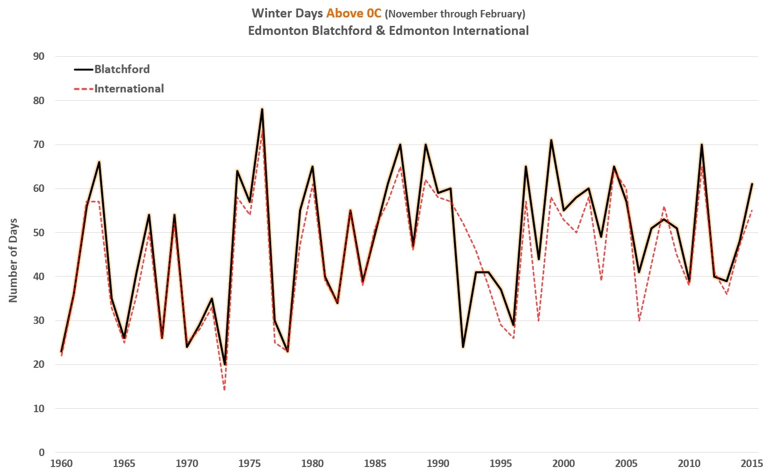
Here we have the number of winter days above 0°C and below -20°C.

And again, similar to what we saw with the rural stations the International has about as many warm days each winter as Edmonton does. For the days below -20°C though, in some years the two stations are within a few days of each other, but in others the International has more than twice as many cold days as the city. For the winter of 2015-2016 it was 6 days below -20°C in Edmonton compared to 25 at the International.


And the very cold days are similar. The International frequently sees 10 or 20 days below -30°C each year, where Edmonton will have 1 or 2 or often none.  And it has been over 40 years since a day below -40°C was recorded in Edmonton, but the International still gets those every few years.

Looking at all of that, it seems like the High temperatures and the warm days aren't very interesting. So for the rest of this post I'll just focus on the cold days, and instead of going all the way back to 1960 we'll stick with the more recent history back to 1997.


Here we have the low temperatures for the International compared to each day's low temperature in Edmonton. And we can see that the International is generally a little colder. For some examples:
  • 0°C in Edmonton: about -3°C at the International, with a range of 0°C to -5°C
  • -10°C in Edmonton: about -13°C, with a range of -9°C to -18°C
  • -20°C in Edmonton: about -24°C, with a range of -20°C to -30°C


To make a bit more sense of all of those datapoints, here is the average temperature difference between Edmonton and the International.

It's interesting that when Edmonton is between 0°C and -20°C, the International is typically only about 3 to 4°C colder. But once the temperature drops below -20°C that gap gets much larger, reaching 8 to 9°C on the very coldest days.

A problem with this chart is that for the coldest temperatures there aren't very many results, and so the "averages" are really just extremes or outliers. That is the reason that the line jumps around below -30°C. But thinking about those rare occasions when Edmonton claims the title "The 2nd coldest place on earth!" maybe the outliers and the extremes are the place to look.


Here are the International Airport's 100 coldest days since 1997, and the corresponding temperatures in Edmonton. I think this one gets to the heart of the issue.

On those really, really, really cold days, Edmonton is typically 8 to 9°C warmer than the airport. That's still cold, but it's arctic rather than martian. Of those 100 days there were 24 when Edmonton was actually 10°C or more warmer than the International, and only 3 when the difference was less than 5°C.

So just how cold is the Edmonton International Airport? Well, for most of the winter it's just a few degrees cooler than Edmonton. But when it gets cold, it gets really cold. Remember to plug your car in.

Update: If you'd like to know even more about the International Airport, I've done a followup to this The Edmonton International Airport: Part 2 which takes an even closer look, and which includes a comparison to airports in Calgary and Winnipeg.

2016/04/04

2015-2016 Winter in Review


These are the daily High temperatures for 2015-2016 compared to those going back through 1997-1998. It's a surprisingly pretty chart, but there is a lot of stuff going on, so it needs some explanation.

The black line is 2015-2016, and the white line is the average for the period. That average is similar to the "normals" that are mentioned in weather reports, but those typically take 30 years into account, while here I am just using data from the current Blatchford weather station which only goes back to 1997.

The thick grey band is the 25th through 75th percentiles. This just means that half of the time the daily high will fall within that range. Then there are the highest and lowest values recorded since 1997. And I have also included the 2nd highest and 2nd lowest, because some of the extreme days really are extreme outliers.

So with that said, looking at the history we see that things cool from November through mid-January, and then start to warm up again heading into spring.

This year the Highs were above average for most of the winter, and they didn't get close to any of the coldest values. They only fell below the 25th percentile on a handful of occasions.


The Low temperatures tell a similar story, being above average for most of the winter, except for a stretch from mid-December through mid-January where temperatures were just a bit below normal.


Here are the same charts with some of the dates highlighted, so that things pop a little bit more.

This year there were 11 days that recorded the warmest temperature for the period. 11 days might sound like a lot, but since we are only going back to 1997 we would actually expect that every year will record about 8 of those. So while 11 is a bit more than that, it's not huge.

In terms of Highs that were below the average, there were 43 out of 152 days, or 28%. And none of those came close to the coldest temperatures that had been recorded for the period.


The daytime Lows are fairly similar. 17 days had the warmest low temperatures recorded since 1997. Only 38 days were below the average. And none were close to the coldest temperatures.


Here was have 2015-2016 compared against just the last 5 years. I'm not concerned about the specifics of 2010 through 2014, so they are all in the background to make this year stand out.

And what stands out is that 2015-2016 was very much at the top of the pack for November, February and March. And it was only for mid-December through late-January that temperatures fell to more normal levels.


Thinking back to my look at "A winter without -20C?", in the last 5 years 2010-2011 was a particularly cold winter, and 2011-2012 was a warm one. So here we have those two years compared against 2015-2016.

The biggest difference between 2010-2011 and the two warm years is just how cold February and March were, with weeks of -20°C and -25°C lasting until almost the start of spring. That year had almost a month-and-a-half of extra real winter.

Of the two warm years, 2011-2012 was actually more consistently warm than 2015-2016. It didn't have the month long December-January coldsnap that we had this year. But it did have a handful of very cold days, dropping below -30°C in mid-January.

The whole reason that I started looking at weather data this year was because of the little chinook that we got in mid-January. Everyone was saying "Don't get used to it, because it never gets this nice in January." But I've been running and walking and cycling for enough winters now that I thought, "waitaminute, doesn't this always happen?"

And here we see that all three of these years did have chinooks in January - and not just small ones either, but with temperatures reaching 8°C to 10°C. And going back to 1997-1998, 18 of the 19 January's had a week or more above freezing. 1999 was the only one that didn't, and even it managed a few scattered days at 5°C. So this blog was ultimately started because of one fairly typical week, in a slightly colder than average month, in an otherwise warm winter.


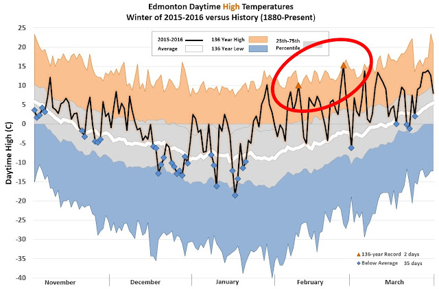
Finally, here is a comparison of 2015-2016 against the temperatures going all the way back to old-timey 1880. This is just for fun, because we know that temperatures have changed since then, so it's not really a fair comparison.

Looking at the 136-year values, we did set a few warm records this year, but obviously no cold ones. And with over a century of data the 25th-75th percentile band has widened a bit, so that the winter of 2015-2016 barely drops below the 25th percentile.

We've seen previously that Edmonton's cold temperatures used to be a lot colder, while the warm temperatures haven't changed as dramatically. And we see that here as well, with typically a 20°C gap between this year's coldest temperatures and the all-time record lows.