2017/11/30

November Review / December Preview

It seems like it was ages ago now, but this November started off really cold, before ending off fairly warm.

High Temperatures

We started November with a string of High temperatures that were right at the bottom of what we've seen since 1996, and it included 5 recent records. November 3rd and 8th in particular were almost 15°C below the average, although they were still a few degrees above the all-time historic records.

That cold weather lasted about 3 weeks before temperatures warmed up, and then for the end of the month we were about 5°C or 6°C above average.


The warm end of the month felt positively spring-like, although warm temperatures at the end of November aren't actually all that uncommon. Recently we've had temperatures above 5°C in the last week of November in 2015, 2011, 2009, 2008, etc. The long, cold start to the month (the blue section in the upper-left of this table) was fairly unusual though, with 2006 probably being the closest comparison.

Our average High of -3.5°C was about the same as 2014 and 2012, although those months both started warm and ended cold. The coldest recent November was 2006, with an average High of -6°C. 2006 had 7 days above freezing, this year we had 10, and the average is 18, so we were definitely on the cold-side of things.

As an aside, November of 1917 (on the right side of this table) was really, really warm. It's average High of 10.6°C was 5°C warmer than anything we've seen in the last 20 years, and it was 14°C warmer than November 2017.


Low Temperatures

As usual, the Low temperatures followed a similar pattern to the Highs. We had the same cold start to the month, which was followed by the above-average end.


2017 was one of the rare years where November didn't have any Lows above freezing. In recent history that had also happened in 2006, 2003 and 2000.

2017 also didn't have any Lows below -25°C or -20°C though, although we did come close with -18.5°C and -18.7°C on the 20th and 21st, and a really early -18.0°C on the 4th.

Again on the right side of the table we can see that 1917 was warm, with an average Low of -2.1°C. That matches 2016 which was the warmest year here, and it was 8°C warmer than November 2017.


1917 & 2017

This is a comparison of 1917 and 2017. We first looked at this style of chart here, and it compares the average temperature (of the Highs and the Lows) for each month of the year to the average temperature from the 20th century.

For most of 2017 we've been a few degrees above the 20th century reference, with the exception of a slightly cool March & April, and now a November that was about 4°C below.

1917 spent most of the year a few degrees below the 20th century average, before things exploded in November, which was 8.3°C above the 20th century average. November 1917 was actually the warmest November on record in Edmonton, while 2017 was in 119th spot out of 137.

In December of 1917 the weather took a turn though, which we can see from the big, blue bar. At 11.3°C below the 20th century average that was actually the 3rd coldest December on record.


December Highs

As we head into December, things can be pretty random.

Some years like 2010 have no Highs above freezing, and others have 15, or 18, or even 22 like in 1999. The average number of days above freezing is 10 though, and 3 days above 5°C. On the colder side of things, about one quarter of the time we have had some Highs below -20°C in December.


December Lows

For Low temperatures we can probably expect to spend most of the month below -10°C, and since 1998 the only Decembers that didn't have any Lows below -20°C were 2011 and 2002.


Precipitation

Here we have the total precipitation - snow and rain - for the month. The International Airport recorded 20mm of precipitation, which is right on the average, and just a bit below the 17mm that were recorded last year.

Blatchford recorded 12mm, which makes this the 5th month in the row where Blatchford's precipitation was notably below the International's. So far for 2017 the International has recorded 487mm compared to 373mm at Blatchford.


Snowfall

In terms of snowfall the International was also right on the average this November, with 19cm. And that is a typical amount of snowfall for most of the winter months, with the exception of February which has usually been a bit lower.

Snowdepth

And finally for today, here we have snowdepth. This year we got an early start on Halloween, and that has carried us through November.


When we break that down into averages & quartiles, this November the International has been a bit above the 75th percentile, although the warmspell at the end of the month melted some of that off.

Environment Canada has also started tracking snowdepth at Blatchford again, after a gap of several years. It is shown here as the dotted green line, and it's a few cm below the International. Over the winter we'll hopefully be able to see how the two compare.

November 2017 Summary

Cold start; warm end; average precipitation; a bit more snow on the ground than normal.

2017/11/24

The Cold November Rain?

We had a bit of a downpour yesterday, which raises the question: how often does Edmonton get rain in November?

Here's the answer:

This uses rain data from the International Airport, because the Blatchford weather station doesn't track rain separately from snow. We know that the International can be quite a bit colder than the city, and so there are probably days where the city had rain that aren't included here, because at the airport it fell as snow.

The only years since 1995 with no November rain at the airport were 2001 & 2003, and both 1995 & 1996 each only recorded 0.2mm. The average is 2mm, although that is skewed by 1999 with 9.1mm and the 8.6 last year in 2016.

This year on November 23 the International recorded 1.6mm, which makes it the 9th rainiest November day since 1995. It's the 3rd or 4th rainiest in the back-half of November though, because most of our November rain tends to happen early in the month.

Update:

For a bit more historical context, here are the Airport's November totals going back to the 1960s.

This chart shows the rainfall totals in blue, and the number of days with rain in green. The 5-year averages appear as dotted lines. And things haven't changed too much over they years.

For the rainfall totals the averages are skewed by the occasional Novembers that are really rainy. For the number of rainy days, since about 2007 the average has been a bit higher than it used to be - although that's a small difference of 3-or-4 rainy days instead of 2-or-3.

2017/11/01

October Review / November Preview

October 2017 certainly went out a wintery note, but today we'll take a look back over the whole month.

High Temperatures

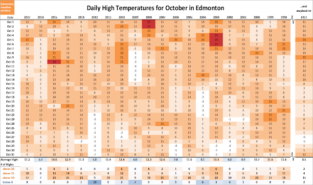
October started pretty warm, but then things cooled off for a week. Then the last half of the month was pretty warm again, with 2 recent records on the 17th and 28th, both just below 20°C. The final few days of the month felt cold, but that was actually pretty close to the average.


Looking at the numbers in more detail, this October was pretty typical. We had one day with a high above 20°C, two weeks above 10°C, and no highs below 0°C. 

Thinking back to last year, 2016 was one of those cold Octobers that we get every few years - along with 2012, 2009, 2006, etc.

Low Temperatures

The path of the Low temperatures is similar to what we saw with the highs - the same coldsnap earlier in the month, and then warm nights later on.


It is a little surprising to think that we actually had 18 Lows below freezing last month, including 2 below -5°C. That isn't unusual, but it is on the cool side of things. Some Octobers like 2013 and 2014 only had 8 night below 0°C.

Warm & Cold Months

So how does October compare overall?

We looked at this chart a few weeks ago, and it compares the average temperature of the whole month to the average from the 20th century. This is a combination of all the daily High and Low temperatures, and October 2017 was just a bit above the 20th century average. It was also quite close to the 5-year average, although that recent average is dragged-down by the cold October 2016.

November Temperatures

As we head into November things are going to cool off. Last November was very warm, with a mini-heatwave to start the month. In a warm year - like 2016, 2009, 2008, 2005 - half of the month might break above 5°C. But in a cold November - like 2013, 2012, 2006 - we might only get 2 or 3.


From 2010-2015 we had a string of Novembers with coldsnaps, with Lows dropping into the range of -18°C all the way down to -30°C in 2014. We didn't get anything like that in November 2016, and that was also a lot more rare prior to 2010. Hopefully those will go back to a once-every-5-years frequency, rather than once-every-year.

Precipitation

In terms of precipitation, with 25mm recorded at the International Airport we were right around the average. Blatchford recorded a little bit less again, at 18mm.

Snow

The International recorded 15cm of snow in October, which was above average, but below what we got in 2016. 5cm of that snow was from the Halloween snowstorm, and the rest was from earlier in the month including 9.2cm on October 1st & 2nd.

Blatchford doesn't record snowfall, but I know that it didn't have a big snowstorm at the beginning of October. When dealing with precipitation or snow I always have to give the caveat that I use the International because its historical data is better than Blatchford's, but unfortunately the International isn't necessarily representative of Blatchford. That's the case here, where the city probably got a total of about 5cm of snow right at the end of the month, compared to the 15cm at the airport.